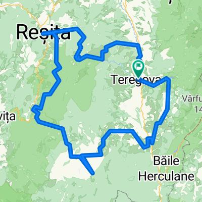
teregova-tabla pocalia- talibanilor bogdanului pasul poarta orientala Vf tomnaticu
A cycling route starting in Teregova, Caraș-Severin County, Romania.
Overview
About this route
- 6 h 22 min
- Duration
- 16.5 km
- Distance
- 961 m
- Ascent
- 964 m
- Descent
- 2.6 km/h
- Avg. speed
- 917 m
- Max. altitude
Route photos
Continue with Bikemap
Use, edit, or download this cycling route
You would like to ride teregova-tabla pocalia- talibanilor bogdanului pasul poarta orientala Vf tomnaticu or customize it for your own trip? Here is what you can do with this Bikemap route:
Free features
- Save this route as favorite or in collections
- Copy & plan your own version of this route
- Sync your route with Garmin or Wahoo
Premium features
Free trial for 3 days, or one-time payment. More about Bikemap Premium.
- Navigate this route on iOS & Android
- Export a GPX / KML file of this route
- Create your custom printout (try it for free)
- Download this route for offline navigation
Discover more Premium features.
Get Bikemap PremiumFrom our community
Other popular routes starting in Teregova
- Culmea Canicei
- Distance
- 68.8 km
- Ascent
- 1,673 m
- Descent
- 1,673 m
- Location
- Teregova, Caraș-Severin County, Romania
- Teregova - B.Herculane
- Distance
- 63.8 km
- Ascent
- 1,047 m
- Descent
- 1,313 m
- Location
- Teregova, Caraș-Severin County, Romania
- Culmea Cănicea cu întoarcere pe șosea
- Distance
- 64.5 km
- Ascent
- 1,563 m
- Descent
- 1,564 m
- Location
- Teregova, Caraș-Severin County, Romania
- Teregova Trei Ape Teregova v1
- Distance
- 36.9 km
- Ascent
- 962 m
- Descent
- 961 m
- Location
- Teregova, Caraș-Severin County, Romania
- Tură cu bicicleta pe Culmea Cănicei - var.2
- Distance
- 64.9 km
- Ascent
- 1,449 m
- Descent
- 1,472 m
- Location
- Teregova, Caraș-Severin County, Romania
- Teregova Lacu Trei Ape
- Distance
- 54.1 km
- Ascent
- 1,138 m
- Descent
- 732 m
- Location
- Teregova, Caraș-Severin County, Romania
- completed Teregova - Putna
- Distance
- 41.4 km
- Ascent
- 825 m
- Descent
- 806 m
- Location
- Teregova, Caraș-Severin County, Romania
- teregova-tabla pocalia- talibanilor bogdanului pasul poarta orientala Vf tomnaticu
- Distance
- 16.5 km
- Ascent
- 961 m
- Descent
- 964 m
- Location
- Teregova, Caraș-Severin County, Romania
Open it in the app