
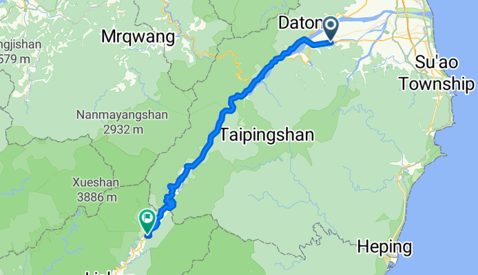
宜蘭(7丙)-武陵農場
A cycling route starting in Yilan, Taiwan, Taiwan.
Overview
About this route
- -:--
- Duration
- 72.8 km
- Distance
- 2,023 m
- Ascent
- 277 m
- Descent
- ---
- Avg. speed
- ---
- Max. altitude

Continue with Bikemap
Use, edit, or download this cycling route
You would like to ride 宜蘭(7丙)-武陵農場 or customize it for your own trip? Here is what you can do with this Bikemap route:
Free features
- Save this route as favorite or in collections
- Copy & plan your own version of this route
- Sync your route with Garmin or Wahoo
Premium features
Free trial for 3 days, or one-time payment. More about Bikemap Premium.
- Navigate this route on iOS & Android
- Export a GPX / KML file of this route
- Create your custom printout (try it for free)
- Download this route for offline navigation
Discover more Premium features.
Get Bikemap PremiumFrom our community
Other popular routes starting in Yilan
 橫越中央山脈一豎,台7甲,台14甲,台21,台18線
- Distance
- 409.2 km
- Ascent
- 6,042 m
- Descent
- 6,044 m
- Location
- Yilan, Taiwan, Taiwan
 北濱公路 : 宜蘭市->內湖 101km
- Distance
- 101.7 km
- Ascent
- 567 m
- Descent
- 550 m
- Location
- Yilan, Taiwan, Taiwan
 980502_桶后林道
- Distance
- 11.8 km
- Ascent
- 625 m
- Descent
- 418 m
- Location
- Yilan, Taiwan, Taiwan
 太平山
太平山- Distance
- 35.5 km
- Ascent
- 2,002 m
- Descent
- 247 m
- Location
- Yilan, Taiwan, Taiwan
 宜蘭(7丙)-武陵農場
- Distance
- 72.8 km
- Ascent
- 2,023 m
- Descent
- 277 m
- Location
- Yilan, Taiwan, Taiwan
 小鐵人宜蘭兩日20160424
- Distance
- 63.8 km
- Ascent
- 1,085 m
- Descent
- 1,078 m
- Location
- Yilan, Taiwan, Taiwan
 北進武嶺 (至埔里轉運站)
- Distance
- 203.5 km
- Ascent
- 3,755 m
- Descent
- 3,316 m
- Location
- Yilan, Taiwan, Taiwan
 Day 9 Tai Wan
- Distance
- 81.8 km
- Ascent
- 228 m
- Descent
- 180 m
- Location
- Yilan, Taiwan, Taiwan
Open it in the app