
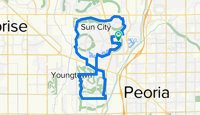
Recovered Route
A cycling route starting in Sun City, Arizona, United States.
Overview
About this route
- 1 h 35 min
- Duration
- 26.4 km
- Distance
- 24 m
- Ascent
- 24 m
- Descent
- 16.6 km/h
- Avg. speed
- 368 m
- Max. altitude

Route quality
Waytypes & surfaces along the route
Waytypes
Quiet road
15.6 km
(59 %)
Road
8.7 km
(33 %)
Surfaces
Paved
23.7 km
(90 %)
Asphalt
23.7 km
(90 %)
Undefined
2.6 km
(10 %)
Continue with Bikemap
Use, edit, or download this cycling route
You would like to ride Recovered Route or customize it for your own trip? Here is what you can do with this Bikemap route:
Free features
- Save this route as favorite or in collections
- Copy & plan your own version of this route
- Sync your route with Garmin or Wahoo
Premium features
Free trial for 3 days, or one-time payment. More about Bikemap Premium.
- Navigate this route on iOS & Android
- Export a GPX / KML file of this route
- Create your custom printout (try it for free)
- Download this route for offline navigation
Discover more Premium features.
Get Bikemap PremiumFrom our community
Other popular routes starting in Sun City
 Rio Vista loop short
- Distance
- 8 km
- Ascent
- 11 m
- Descent
- 10 m
- Location
- Sun City, Arizona, United States
 W Buckskin Trail, Phoenix to W Buckskin Trail, Phoenix
- Distance
- 13.1 km
- Ascent
- 41 m
- Descent
- 46 m
- Location
- Sun City, Arizona, United States
 Arrohead lakes
- Distance
- 6.6 km
- Ascent
- 27 m
- Descent
- 17 m
- Location
- Sun City, Arizona, United States
 Route to 7160 West Irma Lane, Glendale, AZ 85308
- Distance
- 37.1 km
- Ascent
- 74 m
- Descent
- 74 m
- Location
- Sun City, Arizona, United States
 W Buckskin Trail, Phoenix to N 56th Ave, Phoenix
- Distance
- 17.8 km
- Ascent
- 103 m
- Descent
- 106 m
- Location
- Sun City, Arizona, United States
 testing
- Distance
- 88 km
- Ascent
- 37 m
- Descent
- 77 m
- Location
- Sun City, Arizona, United States
 2013 ABC Desert Classic Century
- Distance
- 167.2 km
- Ascent
- 687 m
- Descent
- 684 m
- Location
- Sun City, Arizona, United States
 Restful ride in
- Distance
- 41.4 km
- Ascent
- 183 m
- Descent
- 202 m
- Location
- Sun City, Arizona, United States
Open it in the app