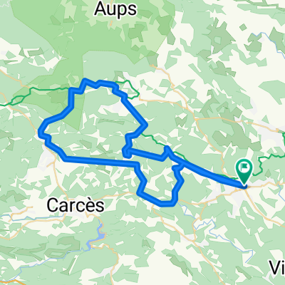
Mt Lachens - Lorgues - 7 Novembre 22_Y.P.
A cycling route starting in Lorgues, Provence-Alpes-CĂ´te d'Azur Region, France.
Overview
About this route
Lorgues – Col de l’Ange ( 242 m ) – Draguignan – Vieille route de Grasse – Cante Perdrix – cote 400 m – Ste Catherine - Figanières ( à côté ) - CV ( anc. voie ferrée ) – Callas - Bargemon - Col du Bel Homme ( 915 m ) – Vieux Brovès ( Ruines ) - La Bastide – Col de Clavel ( 1060 m ) – R.F. – Mt Lachens ( 1714 m ) – R.F. - Col de Clavel – La Martre – Châteauvieux – Col de Siron ( 965 m ) – Brénon – Jabron – Comps sur Artuby ( 890 m ) – Mas de Mathurine ( Canjuers ) – Montferrat - Châteaudouble – Ampus – St Pierre de Tourtour ( 703 m ) – Tourtour – Les Mandins – Château de Berne - Lorgues.
- -:--
- Duration
- 148.4 km
- Distance
- 3,178 m
- Ascent
- 3,178 m
- Descent
- ---
- Avg. speed
- 1,701 m
- Avg. speed
Route quality
Waytypes & surfaces along the route
Waytypes
Busy road
65.9 km
(44 %)
Road
51.3 km
(35 %)
Surfaces
Paved
104.1 km
(70 %)
Unpaved
0.2 km
(<1 %)
Asphalt
104.1 km
(70 %)
Unpaved (undefined)
0.2 km
(<1 %)
Continue with Bikemap
Use, edit, or download this cycling route
You would like to ride Mt Lachens - Lorgues - 7 Novembre 22_Y.P. or customize it for your own trip? Here is what you can do with this Bikemap route:
Free features
- Save this route as favorite or in collections
- Copy & plan your own version of this route
- Sync your route with Garmin or Wahoo
Premium features
Free trial for 3 days, or one-time payment. More about Bikemap Premium.
- Navigate this route on iOS & Android
- Export a GPX / KML file of this route
- Create your custom printout (try it for free)
- Download this route for offline navigation
Discover more Premium features.
Get Bikemap PremiumFrom our community
Other popular routes starting in Lorgues
- Lorgues-Flayosc-Tourtour-Lorgues
- Distance
- 34.9 km
- Ascent
- 754 m
- Descent
- 754 m
- Location
- Lorgues, Provence-Alpes-CĂ´te d'Azur Region, France
- Lorgues-Flayosc-Ampus-Tourtour-Lorgues
- Distance
- 46.7 km
- Ascent
- 628 m
- Descent
- 626 m
- Location
- Lorgues, Provence-Alpes-CĂ´te d'Azur Region, France
- Trainingsrondje Lorgues
- Distance
- 29.9 km
- Ascent
- 368 m
- Descent
- 360 m
- Location
- Lorgues, Provence-Alpes-CĂ´te d'Azur Region, France
- Rute 5
- Distance
- 37.8 km
- Ascent
- 334 m
- Descent
- 334 m
- Location
- Lorgues, Provence-Alpes-CĂ´te d'Azur Region, France
- Lorgues - Salernes
- Distance
- 15.8 km
- Ascent
- 140 m
- Descent
- 122 m
- Location
- Lorgues, Provence-Alpes-CĂ´te d'Azur Region, France
- Lorgues-Grimaud und zurĂĽck
- Distance
- 87.4 km
- Ascent
- 948 m
- Descent
- 959 m
- Location
- Lorgues, Provence-Alpes-CĂ´te d'Azur Region, France
- Haut Var Runde 1
- Distance
- 106.3 km
- Ascent
- 1,810 m
- Descent
- 1,720 m
- Location
- Lorgues, Provence-Alpes-CĂ´te d'Azur Region, France
- Mt Lachens - Lorgues - 7 Novembre 22_Y.P.
- Distance
- 148.4 km
- Ascent
- 3,178 m
- Descent
- 3,178 m
- Location
- Lorgues, Provence-Alpes-CĂ´te d'Azur Region, France
Open it in the app