

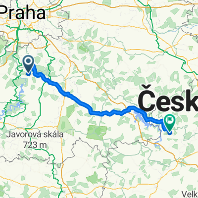
Rakousy - Zampach - Davle - Mednik - Rakousy
A cycling route starting in Kamenný Přívoz, Central Bohemia, Czechia.
Overview
About this route
The start of the route is mainly asphalt, from Kamenný Přívoz to Žampach there's a path (marked with a green tourist sign). The steep climb is on a bad asphalt road, under Studený there is a turnoff onto a gravel road. In Lukách there is asphalt, with some sections utilizing the main road. The ascent through Bohuliby alternates between asphalt and gravel and continues in this manner until the descent into Davle. From Davle to Pikovice is the Posázavská trail - asphalt, solid stone road and path. To Medník via paving stones, gravel and asphalt. The descent to Třebsín is asphalt until the turnoff above the fields before Krňany, the rest is gravel.
- -:--
- Duration
- 31.7 km
- Distance
- 528 m
- Ascent
- 528 m
- Descent
- ---
- Avg. speed
- ---
- Max. altitude

Route quality
Waytypes & surfaces along the route
Waytypes
Quiet road
11.1 km
(35 %)
Track
9.2 km
(29 %)
Surfaces
Paved
3.2 km
(10 %)
Unpaved
9.5 km
(30 %)
Unpaved (undefined)
4.8 km
(15 %)
Gravel
4.1 km
(13 %)
Continue with Bikemap
Use, edit, or download this cycling route
You would like to ride Rakousy - Zampach - Davle - Mednik - Rakousy or customize it for your own trip? Here is what you can do with this Bikemap route:
Free features
- Save this route as favorite or in collections
- Copy & plan your own version of this route
- Sync your route with Garmin or Wahoo
Premium features
Free trial for 3 days, or one-time payment. More about Bikemap Premium.
- Navigate this route on iOS & Android
- Export a GPX / KML file of this route
- Create your custom printout (try it for free)
- Download this route for offline navigation
Discover more Premium features.
Get Bikemap PremiumFrom our community
Other popular routes starting in Kamenný Přívoz
 Borek - Krhanice - Lešany a z kopce zpět
- Distance
- 17 km
- Ascent
- 337 m
- Descent
- 343 m
- Location
- Kamenný Přívoz, Central Bohemia, Czechia
 Okolo Sázavy
- Distance
- 18.8 km
- Ascent
- 462 m
- Descent
- 464 m
- Location
- Kamenný Přívoz, Central Bohemia, Czechia
 Kouty_Luka
- Distance
- 87.8 km
- Ascent
- 927 m
- Descent
- 623 m
- Location
- Kamenný Přívoz, Central Bohemia, Czechia
 Rakousy - Zampach - Davle - Mednik - Rakousy
- Distance
- 31.7 km
- Ascent
- 528 m
- Descent
- 528 m
- Location
- Kamenný Přívoz, Central Bohemia, Czechia
 Rakousy - Pikovice - Davle - Petrov - Pikovice - Třebsín - Rakousy
- Distance
- 24.1 km
- Ascent
- 514 m
- Descent
- 514 m
- Location
- Kamenný Přívoz, Central Bohemia, Czechia
 Cesta do Práce
- Distance
- 22.2 km
- Ascent
- 281 m
- Descent
- 348 m
- Location
- Kamenný Přívoz, Central Bohemia, Czechia
 Rakousy - Homole - Rabyne - Krnany
- Distance
- 37 km
- Ascent
- 748 m
- Descent
- 749 m
- Location
- Kamenný Přívoz, Central Bohemia, Czechia
 Lešany, Lešany naar Trojská, Prague 7
- Distance
- 49.9 km
- Ascent
- 657 m
- Descent
- 787 m
- Location
- Kamenný Přívoz, Central Bohemia, Czechia
Open it in the app