

2022 - Ruta nº 022
- 74.2 km
- 709 m
- 711 m
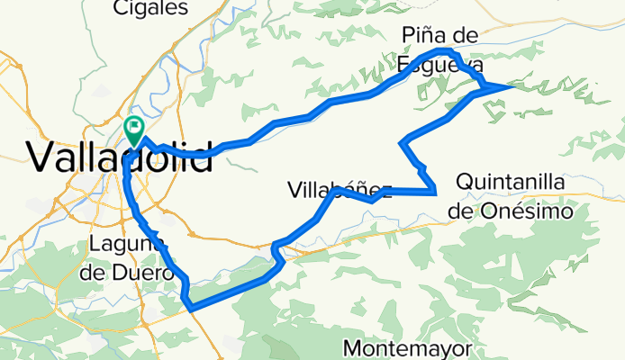
- Valladolid, Castille and León, Spain
A cycling route starting in Valladolid, Castille and León, Spain.
Overview
Renedo -Piña -Castrillo - Villavaquerin- (cruce Olivares) -Villabañez -(Tudela exterior)-Ctra.Maricas -(rotonda el Otero)- La Corala -Valladolid.
1ª Subida: Páramo Alcubilla (1) Pendiente 5,40% - Distancia 2,4 km
2º Subida: Bolinchel Pendiente media 3,00% Distancia 3.00Km.
created this 3 years ago
Route quality
Road
41.4 km
48 %
Quiet road
7.8 km
9 %
Paved
70.7 km
(82 %)
Unpaved
6.9 km
(8 %)
Asphalt
70.7 km
82 %
Ground
6.9 km
8 %
Undefined
8.6 km
10 %
Route highlights
1ª Subida: Páramo Alcubilla (1) Pendiente 5,40% - Distancia 2,4 km
2º Subida: Bolinchel Pendiente media 3,00% Distancia 3.00Km.
Continue with Bikemap
You would like to ride 2023-09-10 Ruta Nº 081 or customize it for your own trip? Here is what you can do with this Bikemap route:
Free trial for 3 days, or one-time payment. More about Bikemap Premium.
Discover more Premium features.
Get Bikemap PremiumFrom our community
Open it in the app


