

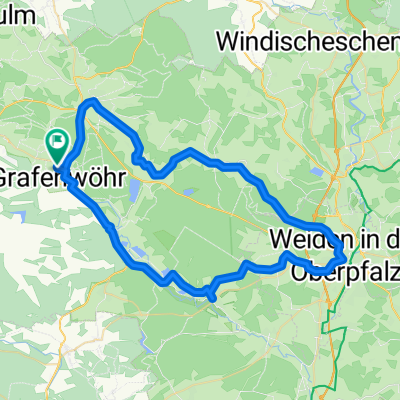
Hütten - Mitterteich
A cycling route starting in Grafenwöhr, Bavaria, Germany.
Overview
About this route
Start from the village square in Hütten
requires some fitness
forest and meadow path
partly poor riding on gravel
not recommended for families
nice cycling paths from Erbendorf
- -:--
- Duration
- 47.5 km
- Distance
- 440 m
- Ascent
- 326 m
- Descent
- ---
- Avg. speed
- ---
- Max. altitude
Route quality
Waytypes & surfaces along the route
Waytypes
Track
12.8 km
(27 %)
Quiet road
10.5 km
(22 %)
Surfaces
Paved
32.8 km
(69 %)
Unpaved
12.8 km
(27 %)
Asphalt
32.8 km
(69 %)
Gravel
11.9 km
(25 %)
Continue with Bikemap
Use, edit, or download this cycling route
You would like to ride Hütten - Mitterteich or customize it for your own trip? Here is what you can do with this Bikemap route:
Free features
- Save this route as favorite or in collections
- Copy & plan your own version of this route
- Sync your route with Garmin or Wahoo
Premium features
Free trial for 3 days, or one-time payment. More about Bikemap Premium.
- Navigate this route on iOS & Android
- Export a GPX / KML file of this route
- Create your custom printout (try it for free)
- Download this route for offline navigation
Discover more Premium features.
Get Bikemap PremiumFrom our community
Other popular routes starting in Grafenwöhr
 Grafenwöhr-Gardasee
- Distance
- 571.7 km
- Ascent
- 2,631 m
- Descent
- 2,976 m
- Location
- Grafenwöhr, Bavaria, Germany
 graf-33km
- Distance
- 32.8 km
- Ascent
- 226 m
- Descent
- 226 m
- Location
- Grafenwöhr, Bavaria, Germany
 Bärnwinkel
- Distance
- 15.1 km
- Ascent
- 48 m
- Descent
- 40 m
- Location
- Grafenwöhr, Bavaria, Germany
 Vilstalradweg
- Distance
- 86.2 km
- Ascent
- 747 m
- Descent
- 747 m
- Location
- Grafenwöhr, Bavaria, Germany
 Blickpunkt Runde
- Distance
- 15.2 km
- Ascent
- 134 m
- Descent
- 133 m
- Location
- Grafenwöhr, Bavaria, Germany
 TDG52
TDG52- Distance
- 80.9 km
- Ascent
- 649 m
- Descent
- 632 m
- Location
- Grafenwöhr, Bavaria, Germany
 weiden and back to home
- Distance
- 59.2 km
- Ascent
- 445 m
- Descent
- 447 m
- Location
- Grafenwöhr, Bavaria, Germany
 abendrunde
- Distance
- 11.2 km
- Ascent
- 71 m
- Descent
- 78 m
- Location
- Grafenwöhr, Bavaria, Germany
Open it in the app