

Pętla (Czechowice-Kobiór-Tychy-Łąka)
A cycling route starting in Czechowice-Dziedzice, Silesian Voivodeship, Poland.
Overview
About this route
Along the airport areas of Kaniów, crossing the Vistula river through mining areas, an attractive path 'by pipeline' through the Pszczyna forests, through the Kobiór forests to Lake Paprocańskie in Tychy and back through the woods to Czarków, crossing the dam in Łąka and returning through the Goczałkowice Forest.
- -:--
- Duration
- 78.1 km
- Distance
- 174 m
- Ascent
- 177 m
- Descent
- ---
- Avg. speed
- 273 m
- Max. altitude
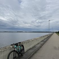
Route photos
\"")
\"")
\"")
\"")
\"")
Continue with Bikemap
Use, edit, or download this cycling route
You would like to ride Pętla (Czechowice-Kobiór-Tychy-Łąka) or customize it for your own trip? Here is what you can do with this Bikemap route:
Free features
- Save this route as favorite or in collections
- Copy & plan your own version of this route
- Sync your route with Garmin or Wahoo
Premium features
Free trial for 3 days, or one-time payment. More about Bikemap Premium.
- Navigate this route on iOS & Android
- Export a GPX / KML file of this route
- Create your custom printout (try it for free)
- Download this route for offline navigation
Discover more Premium features.
Get Bikemap PremiumFrom our community
Other popular routes starting in Czechowice-Dziedzice
 Pętla (Czechowice-Bielsko)
- Distance
- 46.2 km
- Ascent
- 332 m
- Descent
- 333 m
- Location
- Czechowice-Dziedzice, Silesian Voivodeship, Poland
 Przeciągnięta pętla Zbiornik Goczałkowicki
- Distance
- 83.1 km
- Ascent
- 81 m
- Descent
- 81 m
- Location
- Czechowice-Dziedzice, Silesian Voivodeship, Poland
 czechowice-dziedzice
- Distance
- 39.7 km
- Ascent
- 87 m
- Descent
- 86 m
- Location
- Czechowice-Dziedzice, Silesian Voivodeship, Poland
 Towarowa, Czechowice-Dziedzice do R Traugutta, Czechowice-Dziedzice
- Distance
- 50 km
- Ascent
- 274 m
- Descent
- 278 m
- Location
- Czechowice-Dziedzice, Silesian Voivodeship, Poland
 Dwa jeziora.
- Distance
- 65.1 km
- Ascent
- 179 m
- Descent
- 180 m
- Location
- Czechowice-Dziedzice, Silesian Voivodeship, Poland
 Grabowicka 23F, Czechowice-Dziedzice do Grabowicka 23F, Czechowice-Dziedzice
- Distance
- 71.2 km
- Ascent
- 227 m
- Descent
- 225 m
- Location
- Czechowice-Dziedzice, Silesian Voivodeship, Poland
 Pętla (Czechowice-Przegibek-Kozubnik-Kęty)
- Distance
- 71.1 km
- Ascent
- 660 m
- Descent
- 661 m
- Location
- Czechowice-Dziedzice, Silesian Voivodeship, Poland
 Dookoła zapory
- Distance
- 49.3 km
- Ascent
- 101 m
- Descent
- 99 m
- Location
- Czechowice-Dziedzice, Silesian Voivodeship, Poland
Open it in the app