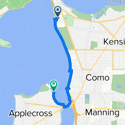
Coode Street 3, South Perth to Basinghall Street 39, East Victoria Park
A cycling route starting in South Perth, Western Australia, Australia.
Overview
About this route
- 31 min
- Duration
- 5.5 km
- Distance
- 152 m
- Ascent
- 133 m
- Descent
- 10.9 km/h
- Avg. speed
- 24 m
- Max. altitude
Route photos
Route quality
Waytypes & surfaces along the route
Waytypes
- Cycleway - 2.5 km - (45 %) 
- Pedestrian area - 0.8 km - (15 %) 
Surfaces
Paved
2.3 km
(41 %)
- Asphalt - 1.4 km - (25 %) 
- Paved (undefined) - 0.8 km - (15 %) 
Continue with Bikemap
Use, edit, or download this cycling route
You would like to ride Coode Street 3, South Perth to Basinghall Street 39, East Victoria Park or customize it for your own trip? Here is what you can do with this Bikemap route:
Free features
- Save this route as favorite or in collections
- Copy & plan your own version of this route
- Sync your route with Garmin or Wahoo
Premium features
Free trial for 3 days, or one-time payment. More about Bikemap Premium.
- Navigate this route on iOS & Android
- Export a GPX / KML file of this route
- Create your custom printout (try it for free)
- Download this route for offline navigation
Discover more Premium features.
Get Bikemap PremiumFrom our community
Other popular routes starting in South Perth
 South Perth Mount Henry Loop South Perth Mount Henry Loop- Distance
- 22.4 km
- Ascent
- 33 m
- Descent
- 34 m
- Location
- South Perth, Western Australia, Australia
 
 Coode Street 3, South Perth to Basinghall Street 39, East Victoria Park Coode Street 3, South Perth to Basinghall Street 39, East Victoria Park- Distance
- 5.5 km
- Ascent
- 152 m
- Descent
- 133 m
- Location
- South Perth, Western Australia, Australia
 
 Home via Optus Home via Optus- Distance
- 13.4 km
- Ascent
- 74 m
- Descent
- 74 m
- Location
- South Perth, Western Australia, Australia
 
 Lengthy bike tour through Perth Lengthy bike tour through Perth- Distance
- 56.2 km
- Ascent
- 180 m
- Descent
- 180 m
- Location
- South Perth, Western Australia, Australia
 
 Recovered Route Recovered Route- Distance
- 5.8 km
- Ascent
- 3 m
- Descent
- 5 m
- Location
- South Perth, Western Australia, Australia
 
 80 km - SP-Ellenbrook-Greenwood-Joondalup 80 km - SP-Ellenbrook-Greenwood-Joondalup- Distance
- 80.4 km
- Ascent
- 741 m
- Descent
- 740 m
- Location
- South Perth, Western Australia, Australia
 
 NarrowsZephyrCafeRiverLoop NarrowsZephyrCafeRiverLoop- Distance
- 48.7 km
- Ascent
- 0 m
- Descent
- 0 m
- Location
- South Perth, Western Australia, Australia
 
 SouthPerthOceanBeachRoundTrip SouthPerthOceanBeachRoundTrip- Distance
- 53.6 km
- Ascent
- 285 m
- Descent
- 285 m
- Location
- South Perth, Western Australia, Australia
 
Open it in the app


