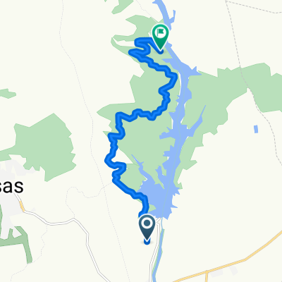
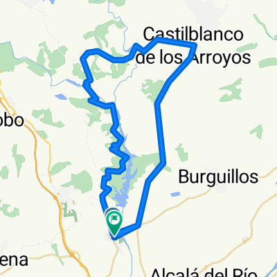
Guillenazo 54km
A cycling route starting in Guillena, Andalusia, Spain.
Overview
About this route
Tipica - guillena - ruta del agua- cuesta de los toros - castiblanco y vuelta por la trialera del camino de santiago
- -:--
- Duration
- 103.5 km
- Distance
- 970 m
- Ascent
- 968 m
- Descent
- ---
- Avg. speed
- ---
- Max. altitude
Route quality
Waytypes & surfaces along the route
Waytypes
Track
64 km
(62 %)
Path
15.8 km
(15 %)
Surfaces
Unpaved
60.1 km
(58 %)
Unpaved (undefined)
34.4 km
(33 %)
Gravel
25.7 km
(25 %)
Undefined
43.4 km
(42 %)
Continue with Bikemap
Use, edit, or download this cycling route
You would like to ride Guillenazo 54km or customize it for your own trip? Here is what you can do with this Bikemap route:
Free features
- Save this route as favorite or in collections
- Copy & plan your own version of this route
- Split it into stages to create a multi-day tour
- Sync your route with Garmin or Wahoo
Premium features
Free trial for 3 days, or one-time payment. More about Bikemap Premium.
- Navigate this route on iOS & Android
- Export a GPX / KML file of this route
- Create your custom printout (try it for free)
- Download this route for offline navigation
Discover more Premium features.
Get Bikemap PremiumFrom our community
Other popular routes starting in Guillena
- Mirador de la Solana
- Distance
- 11.1 km
- Ascent
- 153 m
- Descent
- 76 m
- Location
- Guillena, Andalusia, Spain
- Guillena-El Ronquillo-Guillena
- Distance
- 66.7 km
- Ascent
- 658 m
- Descent
- 657 m
- Location
- Guillena, Andalusia, Spain
- Ruta del Agua
- Distance
- 29.5 km
- Ascent
- 397 m
- Descent
- 394 m
- Location
- Guillena, Andalusia, Spain
- Ruta del agua
- Distance
- 41.4 km
- Ascent
- 784 m
- Descent
- 788 m
- Location
- Guillena, Andalusia, Spain
- Guillena-Kungfu-M.Fanega-Guillena 54kms
- Distance
- 54 km
- Ascent
- 504 m
- Descent
- 504 m
- Location
- Guillena, Andalusia, Spain
- Guillena-Castilblanco
- Distance
- 17.5 km
- Ascent
- 367 m
- Descent
- 39 m
- Location
- Guillena, Andalusia, Spain
- Guillenazo 54km
- Distance
- 103.5 km
- Ascent
- 970 m
- Descent
- 968 m
- Location
- Guillena, Andalusia, Spain
- Ruta del agua [Zona Restringida]
- Distance
- 29.9 km
- Ascent
- 404 m
- Descent
- 404 m
- Location
- Guillena, Andalusia, Spain
Open it in the app