

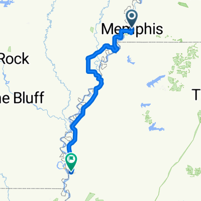
Memphis to St.Louis
A cycling route starting in Memphis, Tennessee, United States.
Overview
About this route
- -:--
- Duration
- 531.9 km
- Distance
- 2,357 m
- Ascent
- 2,295 m
- Descent
- ---
- Avg. speed
- 268 m
- Max. altitude

Route quality
Waytypes & surfaces along the route
Waytypes
Busy road
321.1 km
(60 %)
Quiet road
97.7 km
(18 %)
Surfaces
Paved
182.7 km
(34 %)
Unpaved
9.2 km
(2 %)
Asphalt
156 km
(29 %)
Paved (undefined)
25.7 km
(5 %)
Continue with Bikemap
Use, edit, or download this cycling route
You would like to ride Memphis to St.Louis or customize it for your own trip? Here is what you can do with this Bikemap route:
Free features
- Save this route as favorite or in collections
- Copy & plan your own version of this route
- Split it into stages to create a multi-day tour
- Sync your route with Garmin or Wahoo
Premium features
Free trial for 3 days, or one-time payment. More about Bikemap Premium.
- Navigate this route on iOS & Android
- Export a GPX / KML file of this route
- Create your custom printout (try it for free)
- Download this route for offline navigation
Discover more Premium features.
Get Bikemap PremiumFrom our community
Other popular routes starting in Memphis
 Memphis to Bristol Part 1
- Distance
- 74.2 km
- Ascent
- 417 m
- Descent
- 408 m
- Location
- Memphis, Tennessee, United States
 downtown/big river
- Distance
- 13.5 km
- Ascent
- 172 m
- Descent
- 172 m
- Location
- Memphis, Tennessee, United States
 Steady ride in Memphis
- Distance
- 14.4 km
- Ascent
- 293 m
- Descent
- 278 m
- Location
- Memphis, Tennessee, United States
 Route from the Sheraton Downtown, to Tom Lee Park, ending at Big River Crossing
- Distance
- 9.1 km
- Ascent
- 72 m
- Descent
- 76 m
- Location
- Memphis, Tennessee, United States
 Memphis to Cherokee for Natchez Trace
- Distance
- 274.7 km
- Ascent
- 2,226 m
- Descent
- 2,158 m
- Location
- Memphis, Tennessee, United States
 downtown Main Street
- Distance
- 6 km
- Ascent
- 73 m
- Descent
- 80 m
- Location
- Memphis, Tennessee, United States
 wwwww
wwwww- Distance
- 344.2 km
- Ascent
- 60 m
- Descent
- 92 m
- Location
- Memphis, Tennessee, United States
 125 N Front St, Memphis to 140–144 AR-14, Lead Hill
- Distance
- 404.4 km
- Ascent
- 2,596 m
- Descent
- 2,422 m
- Location
- Memphis, Tennessee, United States
Open it in the app