

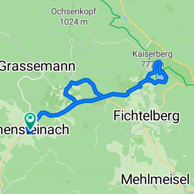
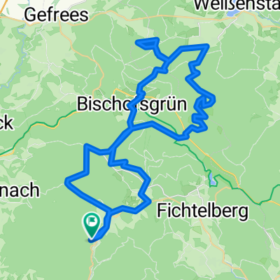
Warmensteinach-Seybothenreuth-Mehlmeisel
A cycling route starting in Warmensteinach, Bavaria, Germany.
Overview
About this route
Beautiful route for ambitious cyclists with all variations, single trail, Camino de Santiago, descent, road. The complete program...
- -:--
- Duration
- 49.4 km
- Distance
- 858 m
- Ascent
- 858 m
- Descent
- ---
- Avg. speed
- ---
- Max. altitude

Route quality
Waytypes & surfaces along the route
Waytypes
Quiet road
21.7 km
(44 %)
Track
21.3 km
(43 %)
Surfaces
Paved
8.9 km
(18 %)
Unpaved
20.3 km
(41 %)
Gravel
16.3 km
(33 %)
Asphalt
8.4 km
(17 %)
Continue with Bikemap
Use, edit, or download this cycling route
You would like to ride Warmensteinach-Seybothenreuth-Mehlmeisel or customize it for your own trip? Here is what you can do with this Bikemap route:
Free features
- Save this route as favorite or in collections
- Copy & plan your own version of this route
- Sync your route with Garmin or Wahoo
Premium features
Free trial for 3 days, or one-time payment. More about Bikemap Premium.
- Navigate this route on iOS & Android
- Export a GPX / KML file of this route
- Create your custom printout (try it for free)
- Download this route for offline navigation
Discover more Premium features.
Get Bikemap PremiumFrom our community
Other popular routes starting in Warmensteinach
 Warmensteinach zum Fichtelsee und zurück:-)
- Distance
- 17.3 km
- Ascent
- 410 m
- Descent
- 416 m
- Location
- Warmensteinach, Bavaria, Germany
 Wanderung Ochsenkopf
- Distance
- 31.8 km
- Ascent
- 640 m
- Descent
- 621 m
- Location
- Warmensteinach, Bavaria, Germany
 Veits-Hans-Weg 220, Warmensteinach nach Veits-Hans-Weg 220, Warmensteinach
- Distance
- 33.4 km
- Ascent
- 698 m
- Descent
- 699 m
- Location
- Warmensteinach, Bavaria, Germany
 Rund um den Ochsenkopf
- Distance
- 49.3 km
- Ascent
- 1,225 m
- Descent
- 1,167 m
- Location
- Warmensteinach, Bavaria, Germany
 Route 2 Schneeberg Fichtelgebirge
- Distance
- 49.6 km
- Ascent
- 1,016 m
- Descent
- 1,030 m
- Location
- Warmensteinach, Bavaria, Germany
 e-bike-tour
- Distance
- 24 km
- Ascent
- 397 m
- Descent
- 397 m
- Location
- Warmensteinach, Bavaria, Germany
 Warmensteinach - Ochsenkopf lanovka
- Distance
- 4.3 km
- Ascent
- 271 m
- Descent
- 89 m
- Location
- Warmensteinach, Bavaria, Germany
 Warmensteinbach
- Distance
- 45.3 km
- Ascent
- 1,074 m
- Descent
- 1,070 m
- Location
- Warmensteinach, Bavaria, Germany
Open it in the app