

Klausenpass und Pragelpass
A cycling route starting in Bürglen, Canton of Uri, Switzerland.
Overview
About this route
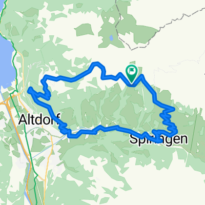
Von Altdorf aus gehts direkt in die ersten Steigungen Richtung Klausenpasshöhe mit verschiedenen Flachteilen bei Bürglen und Unterschächen. Auf dem Klausen sind die ersten 1490 Höhenmeter bewältigt; aber das ist noch nicht alles. In der Abfahrt auf der engen Ostseite der Passstrasse via Urnerboden gelangen wir ins Glarnerland. Vom Talboden ab Linthal (660 müM) hast du öfters starken Gegenwind bis nach Glarus alsHauptort des Kantons. Wenige Kilometer ausserhalb geht es wieder bergauf Richtung Klöntalersee und weiter auf den Pragelpass (1550 müM), welcher an Wochenenden für den Autoverkehr gesperrt ist. In einer langen Abfahrt via Muothatal gelangt man wieder via Schwyz - Brunnen an die Ufer des Vierwald-stättersees. Über die berüchtigte Axenstrasse (häufig viel Verkehr) geht es zurück nach Altdorf. Als Alternative kann von Brunnen nach Flüelen das Schiff genutzt werden.
- -:--
- Duration
- 129.6 km
- Distance
- 2,849 m
- Ascent
- 2,849 m
- Descent
- ---
- Avg. speed
- ---
- Max. altitude

Route quality
Waytypes & surfaces along the route
Waytypes
Busy road
62.4 km
(48 %)
Road
23.5 km
(18 %)
Surfaces
Paved
99 km
(76 %)
Unpaved
7.9 km
(6 %)
Asphalt
95.8 km
(74 %)
Gravel
4.6 km
(4 %)
Continue with Bikemap
Use, edit, or download this cycling route
You would like to ride Klausenpass und Pragelpass or customize it for your own trip? Here is what you can do with this Bikemap route:
Free features
- Save this route as favorite or in collections
- Copy & plan your own version of this route
- Split it into stages to create a multi-day tour
- Sync your route with Garmin or Wahoo
Premium features
Free trial for 3 days, or one-time payment. More about Bikemap Premium.
- Navigate this route on iOS & Android
- Export a GPX / KML file of this route
- Create your custom printout (try it for free)
- Download this route for offline navigation
Discover more Premium features.
Get Bikemap PremiumFrom our community
Other popular routes starting in Bürglen
 Vordere Weissenboden 4, Bürglen UR to Vordere Weissenboden 4, Bürglen UR
- Distance
- 31.9 km
- Ascent
- 1,330 m
- Descent
- 1,330 m
- Location
- Bürglen, Canton of Uri, Switzerland
 Haldi Lehn Im Wald Verfahren 28.5.
- Distance
- 15.3 km
- Ascent
- 199 m
- Descent
- 1,081 m
- Location
- Bürglen, Canton of Uri, Switzerland
 Klausenpass Langen (Bregenz) 180 km
- Distance
- 178.9 km
- Ascent
- 1,402 m
- Descent
- 2,074 m
- Location
- Bürglen, Canton of Uri, Switzerland
 Panoramatour Urigen-Biel-Eggbergen-Altdorf
- Distance
- 22.6 km
- Ascent
- 830 m
- Descent
- 1,260 m
- Location
- Bürglen, Canton of Uri, Switzerland
 Walsermätteli, Bürglen UR nach Äsch, Unterschächen UR und retour nach Walsermätteli, Bürglen UR
- Distance
- 26.4 km
- Ascent
- 787 m
- Descent
- 786 m
- Location
- Bürglen, Canton of Uri, Switzerland
 Schnelle Radrunde von Haldi bei Schattdorf nach Altdorf UR
- Distance
- 6.1 km
- Ascent
- 44 m
- Descent
- 777 m
- Location
- Bürglen, Canton of Uri, Switzerland
 Klausenpass_Pragelpass_Bisistal_Illgau
- Distance
- 158.2 km
- Ascent
- 4,394 m
- Descent
- 4,531 m
- Location
- Bürglen, Canton of Uri, Switzerland
 Burglen Klausenpass Linthal 45 km (Andermatt)
- Distance
- 44.1 km
- Ascent
- 1,374 m
- Descent
- 1,284 m
- Location
- Bürglen, Canton of Uri, Switzerland
Open it in the app