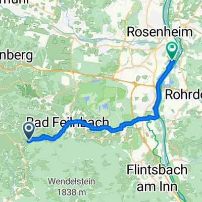
0OB09 : Bad Feilnbach - Bad Aibling - Kolbermoor - Bad Feilnbach
A cycling route starting in Bad Feilnbach, Bavaria, Germany.
Overview
About this route
Parkplatz Bahnhofstraße in Bad Feilnbach || Bad Feilbach - Au bei Bad Aibling - Dettendorf - Bad Aibling - Kolbermoor - Westerndorf - Kleinholzhausen - Wiechs - Bad Feilbach || Empfehlung Eis Pause in Bad Aibling an der Bahnhofstraße || Biergärten an der Route vorhanden - Ruhetage beachten
- -:--
- Duration
- 39.5 km
- Distance
- 169 m
- Ascent
- 167 m
- Descent
- ---
- Avg. speed
- 518 m
- Max. altitude
Route photos
Route quality
Waytypes & surfaces along the route
Waytypes
Quiet road
17.8 km
(45 %)
Path
15.4 km
(39 %)
Surfaces
Paved
32 km
(81 %)
Unpaved
6.7 km
(17 %)
Asphalt
32 km
(81 %)
Loose gravel
5.5 km
(14 %)
Continue with Bikemap
Use, edit, or download this cycling route
You would like to ride 0OB09 : Bad Feilnbach - Bad Aibling - Kolbermoor - Bad Feilnbach or customize it for your own trip? Here is what you can do with this Bikemap route:
Free features
- Save this route as favorite or in collections
- Copy & plan your own version of this route
- Sync your route with Garmin or Wahoo
Premium features
Free trial for 3 days, or one-time payment. More about Bikemap Premium.
- Navigate this route on iOS & Android
- Export a GPX / KML file of this route
- Create your custom printout (try it for free)
- Download this route for offline navigation
Discover more Premium features.
Get Bikemap PremiumFrom our community
Other popular routes starting in Bad Feilnbach
- Von Bad Feilnbach zum Wendelstein und über die Tregleralm
- Distance
- 24.4 km
- Ascent
- 1,015 m
- Descent
- 1,015 m
- Location
- Bad Feilnbach, Bavaria, Germany
- tregler alm bad Aibling
- Distance
- 17.7 km
- Ascent
- 118 m
- Descent
- 585 m
- Location
- Bad Feilnbach, Bavaria, Germany
- Am Farrenpoint vorbeigeschrammt
- Distance
- 9.2 km
- Ascent
- 534 m
- Descent
- 533 m
- Location
- Bad Feilnbach, Bavaria, Germany
- Sulzberg-Wanderung
- Distance
- 9 km
- Ascent
- 678 m
- Descent
- 675 m
- Location
- Bad Feilnbach, Bavaria, Germany
- Schwarzenbergtour
- Distance
- 11.3 km
- Ascent
- 551 m
- Descent
- 550 m
- Location
- Bad Feilnbach, Bavaria, Germany
- Bad Feilnbach Spazierweg
- Distance
- 7.4 km
- Ascent
- 81 m
- Descent
- 81 m
- Location
- Bad Feilnbach, Bavaria, Germany
- 900hm
- Distance
- 53.3 km
- Ascent
- 1,066 m
- Descent
- 878 m
- Location
- Bad Feilnbach, Bavaria, Germany
- SC 53_Wendelstein 110km
- Distance
- 108.8 km
- Ascent
- 1,179 m
- Descent
- 1,179 m
- Location
- Bad Feilnbach, Bavaria, Germany
Open it in the app