
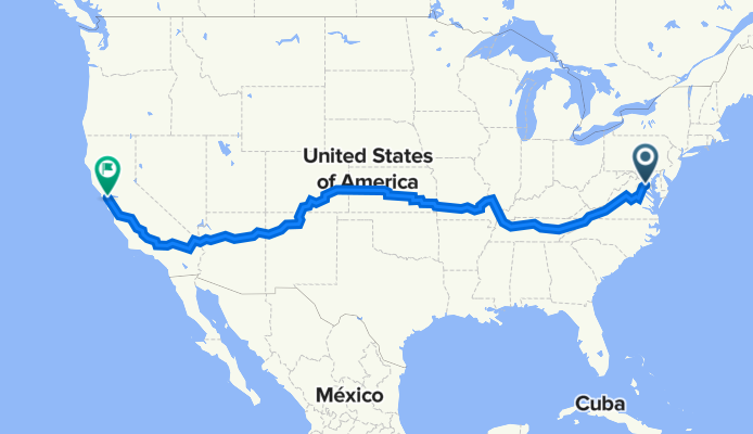
North Saint Asaph Street 730, Alexandria nach Giant Highway 5551, Richmond
A cycling route starting in Alexandria, Virginia, United States.
Overview
About this route
- 371 h 12 min
- Duration
- 5,870.7 km
- Distance
- 48,011 m
- Ascent
- 48,025 m
- Descent
- 15.8 km/h
- Avg. speed
- 3,059 m
- Max. altitude

Route quality
Waytypes & surfaces along the route
Waytypes
Road
1,467.7 km
(25 %)
Quiet road
1,291.5 km
(22 %)
Surfaces
Paved
1,996 km
(34 %)
Unpaved
587.1 km
(10 %)
Asphalt
1,409 km
(24 %)
Paved (undefined)
587.1 km
(10 %)
Continue with Bikemap
Use, edit, or download this cycling route
You would like to ride North Saint Asaph Street 730, Alexandria nach Giant Highway 5551, Richmond or customize it for your own trip? Here is what you can do with this Bikemap route:
Free features
- Save this route as favorite or in collections
- Copy & plan your own version of this route
- Split it into stages to create a multi-day tour
- Sync your route with Garmin or Wahoo
Premium features
Free trial for 3 days, or one-time payment. More about Bikemap Premium.
- Navigate this route on iOS & Android
- Export a GPX / KML file of this route
- Create your custom printout (try it for free)
- Download this route for offline navigation
Discover more Premium features.
Get Bikemap PremiumFrom our community
Other popular routes starting in Alexandria
 Potomac Heritage National Scenic Trail, Alexandria to Mount Vernon Trail, Alexandria
- Distance
- 6.1 km
- Ascent
- 37 m
- Descent
- 37 m
- Location
- Alexandria, Virginia, United States
 Mount Vernon
- Distance
- 24.8 km
- Ascent
- 106 m
- Descent
- 106 m
- Location
- Alexandria, Virginia, United States
 Old Town to Mount Vernon
- Distance
- 17.9 km
- Ascent
- 139 m
- Descent
- 156 m
- Location
- Alexandria, Virginia, United States
 3925 Old Dominion Blvd, Alexandria to 3917 Old Dominion Blvd, Alexandria
- Distance
- 14 km
- Ascent
- 0 m
- Descent
- 3 m
- Location
- Alexandria, Virginia, United States
 Alexandria
- Distance
- 17.5 km
- Ascent
- 1,245 m
- Descent
- 1,241 m
- Location
- Alexandria, Virginia, United States
 Crystal City to Rock Creek Park
- Distance
- 17.2 km
- Ascent
- 231 m
- Descent
- 157 m
- Location
- Alexandria, Virginia, United States
 Strand St, Alexandria to West Potomac Park, Washington
- Distance
- 17.3 km
- Ascent
- 66 m
- Descent
- 60 m
- Location
- Alexandria, Virginia, United States
 Braddock Metro to Fort Hunt round trip
- Distance
- 31.4 km
- Ascent
- 92 m
- Descent
- 92 m
- Location
- Alexandria, Virginia, United States
Open it in the app