

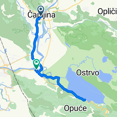
Ćirinom - Oko Hutova blata
A cycling route starting in Tasovčići, Federation of Bosnia and Herzegovina, Bosnia and Herzegovina.
Overview
About this route
- -:--
- Duration
- 51.8 km
- Distance
- 867 m
- Ascent
- 866 m
- Descent
- ---
- Avg. speed
- 268 m
- Max. altitude

Route quality
Waytypes & surfaces along the route
Waytypes
Quiet road
28.5 km
(55 %)
Track
9.3 km
(18 %)
Surfaces
Paved
11.4 km
(22 %)
Unpaved
9.3 km
(18 %)
Asphalt
11.4 km
(22 %)
Gravel
8.8 km
(17 %)
Continue with Bikemap
Use, edit, or download this cycling route
You would like to ride Ćirinom - Oko Hutova blata or customize it for your own trip? Here is what you can do with this Bikemap route:
Free features
- Save this route as favorite or in collections
- Copy & plan your own version of this route
- Sync your route with Garmin or Wahoo
Premium features
Free trial for 3 days, or one-time payment. More about Bikemap Premium.
- Navigate this route on iOS & Android
- Export a GPX / KML file of this route
- Create your custom printout (try it for free)
- Download this route for offline navigation
Discover more Premium features.
Get Bikemap PremiumFrom our community
Other popular routes starting in Tasovčići
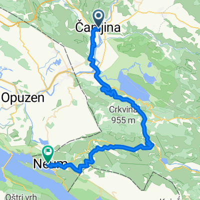 Ciro to Neum
- Distance
- 55.1 km
- Ascent
- 1,327 m
- Descent
- 1,307 m
- Location
- Tasovčići, Federation of Bosnia and Herzegovina, Bosnia and Herzegovina
 Od Kule do Kule
- Distance
- 16.9 km
- Ascent
- 45 m
- Descent
- 42 m
- Location
- Tasovčići, Federation of Bosnia and Herzegovina, Bosnia and Herzegovina
 Krug sa starog mosta u Čapljini do Karaotoka
- Distance
- 21.7 km
- Ascent
- 81 m
- Descent
- 81 m
- Location
- Tasovčići, Federation of Bosnia and Herzegovina, Bosnia and Herzegovina
 Capljina - lake - Drakevo
- Distance
- 25.1 km
- Ascent
- 342 m
- Descent
- 328 m
- Location
- Tasovčići, Federation of Bosnia and Herzegovina, Bosnia and Herzegovina
 Čapljina - Svitava - Neum - Ploče - Ljubuški - Čapljina
- Distance
- 134.9 km
- Ascent
- 1,086 m
- Descent
- 1,085 m
- Location
- Tasovčići, Federation of Bosnia and Herzegovina, Bosnia and Herzegovina
 Ćirinom - Oko Hutova blata
- Distance
- 51.8 km
- Ascent
- 867 m
- Descent
- 866 m
- Location
- Tasovčići, Federation of Bosnia and Herzegovina, Bosnia and Herzegovina
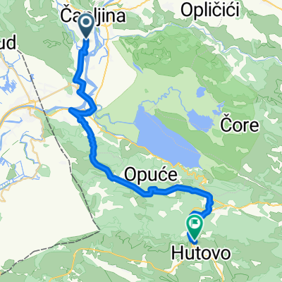 Capljina-Hutovo
- Distance
- 29.4 km
- Ascent
- 802 m
- Descent
- 528 m
- Location
- Tasovčići, Federation of Bosnia and Herzegovina, Bosnia and Herzegovina
 3P86+WG4, Gabela to 3P86+WG4, Gabela
- Distance
- 39.7 km
- Ascent
- 450 m
- Descent
- 452 m
- Location
- Tasovčići, Federation of Bosnia and Herzegovina, Bosnia and Herzegovina
Open it in the app