

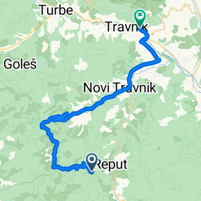
Novi Travnik naar Spomen-park Vraca, Sarajevo
A cycling route starting in Novi Travnik, Federation of Bosnia and Herzegovina, Bosnia and Herzegovina.
Overview
About this route
- 7 h 7 min
- Duration
- 100.2 km
- Distance
- 1,617 m
- Ascent
- 1,499 m
- Descent
- 14.1 km/h
- Avg. speed
- 794 m
- Max. altitude

Route quality
Waytypes & surfaces along the route
Waytypes
Quiet road
36.1 km
(36 %)
Cycleway
6 km
(6 %)
Surfaces
Paved
68.1 km
(68 %)
Unpaved
2 km
(2 %)
Asphalt
67.1 km
(67 %)
Gravel
2 km
(2 %)
Continue with Bikemap
Use, edit, or download this cycling route
You would like to ride Novi Travnik naar Spomen-park Vraca, Sarajevo or customize it for your own trip? Here is what you can do with this Bikemap route:
Free features
- Save this route as favorite or in collections
- Copy & plan your own version of this route
- Split it into stages to create a multi-day tour
- Sync your route with Garmin or Wahoo
Premium features
Free trial for 3 days, or one-time payment. More about Bikemap Premium.
- Navigate this route on iOS & Android
- Export a GPX / KML file of this route
- Create your custom printout (try it for free)
- Download this route for offline navigation
Discover more Premium features.
Get Bikemap PremiumFrom our community
Other popular routes starting in Novi Travnik
 Novi Travnik naar Spomen-park Vraca, Sarajevo
- Distance
- 100.2 km
- Ascent
- 1,617 m
- Descent
- 1,499 m
- Location
- Novi Travnik, Federation of Bosnia and Herzegovina, Bosnia and Herzegovina
 Bosnien und Herzegowina nach Sulejmana Kapića 6, Donji Vakuf
- Distance
- 59.5 km
- Ascent
- 2,552 m
- Descent
- 3,061 m
- Location
- Novi Travnik, Federation of Bosnia and Herzegovina, Bosnia and Herzegovina
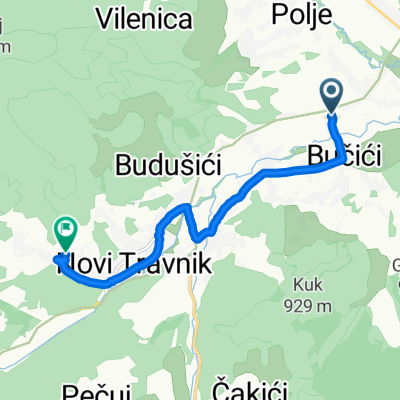
 Novi Travnik to Spalatobahn, Travnik
- Distance
- 34.5 km
- Ascent
- 402 m
- Descent
- 789 m
- Location
- Novi Travnik, Federation of Bosnia and Herzegovina, Bosnia and Herzegovina
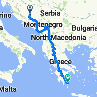 Balkan
- Distance
- 1,993.5 km
- Ascent
- 9,463 m
- Descent
- 9,949 m
- Location
- Novi Travnik, Federation of Bosnia and Herzegovina, Bosnia and Herzegovina
 heehsh
- Distance
- 25.7 km
- Ascent
- 1,150 m
- Descent
- 1,605 m
- Location
- Novi Travnik, Federation of Bosnia and Herzegovina, Bosnia and Herzegovina
 travnik
- Distance
- 28 km
- Ascent
- 1,105 m
- Descent
- 1,594 m
- Location
- Novi Travnik, Federation of Bosnia and Herzegovina, Bosnia and Herzegovina
 Snail-like route in
- Distance
- 8.1 km
- Ascent
- 247 m
- Descent
- 175 m
- Location
- Novi Travnik, Federation of Bosnia and Herzegovina, Bosnia and Herzegovina
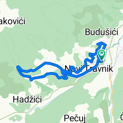 Uzduž i poprijeko NT
- Distance
- 13 km
- Ascent
- 282 m
- Descent
- 284 m
- Location
- Novi Travnik, Federation of Bosnia and Herzegovina, Bosnia and Herzegovina
Open it in the app