
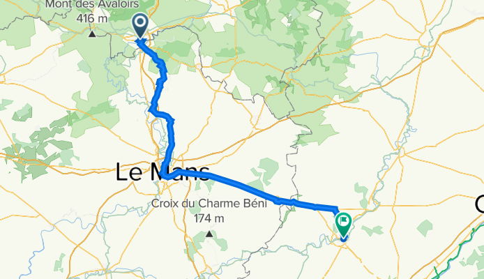
*04-M. Alençon - Vendôme (142 Km)
A cycling route starting in Alençon, Normandy, France.
Overview
About this route
- -:--
- Duration
- 142 km
- Distance
- 1,009 m
- Ascent
- 1,073 m
- Descent
- ---
- Avg. speed
- 195 m
- Max. altitude
Route quality
Waytypes & surfaces along the route
Waytypes
Road
41.2 km
(29 %)
Quiet road
27 km
(19 %)
Surfaces
Paved
83.8 km
(59 %)
Unpaved
1.4 km
(1 %)
Asphalt
83.8 km
(59 %)
Ground
1.4 km
(1 %)
Undefined
56.8 km
(40 %)
Route highlights
Points of interest along the route
Point of interest after 107.2 km
Sprint SAINT-CALAIS Km. 108
Continue with Bikemap
Use, edit, or download this cycling route
You would like to ride *04-M. Alençon - Vendôme (142 Km) or customize it for your own trip? Here is what you can do with this Bikemap route:
Free features
- Save this route as favorite or in collections
- Copy & plan your own version of this route
- Split it into stages to create a multi-day tour
- Sync your route with Garmin or Wahoo
Premium features
Free trial for 3 days, or one-time payment. More about Bikemap Premium.
- Navigate this route on iOS & Android
- Export a GPX / KML file of this route
- Create your custom printout (try it for free)
- Download this route for offline navigation
Discover more Premium features.
Get Bikemap PremiumFrom our community
Other popular routes starting in Alençon
 Alençon-Radon-le mêle sur Sarthe
- Distance
- 65.2 km
- Ascent
- 372 m
- Descent
- 376 m
- Location
- Alençon, Normandy, France
 Voie comme un escargot dans Neuilly-le-Bisson
- Distance
- 67 km
- Ascent
- 801 m
- Descent
- 801 m
- Location
- Alençon, Normandy, France
 Alençon - Beaumont sur Sarthe (65) - Le Mans (43)
- Distance
- 108.3 km
- Ascent
- 861 m
- Descent
- 941 m
- Location
- Alençon, Normandy, France
 17–27 Sente aux Moines, Alençon to 19 Allée des Tilleuls, Alençon
- Distance
- 14.2 km
- Ascent
- 48 m
- Descent
- 87 m
- Location
- Alençon, Normandy, France
 Véloscénie étape 4
- Distance
- 54.6 km
- Ascent
- 546 m
- Descent
- 476 m
- Location
- Alençon, Normandy, France
 Dag 7 - La Flèche - Alençon (wo 17/7) OPTIE 1
- Distance
- 99 km
- Ascent
- 300 m
- Descent
- 406 m
- Location
- Alençon, Normandy, France
 Ecouves Chaumont Avaloirs
- Distance
- 41.6 km
- Ascent
- 677 m
- Descent
- 405 m
- Location
- Alençon, Normandy, France
 B/F Alençon - Condé-sur-Huisne
- Distance
- 67.1 km
- Ascent
- 281 m
- Descent
- 307 m
- Location
- Alençon, Normandy, France
Open it in the app