
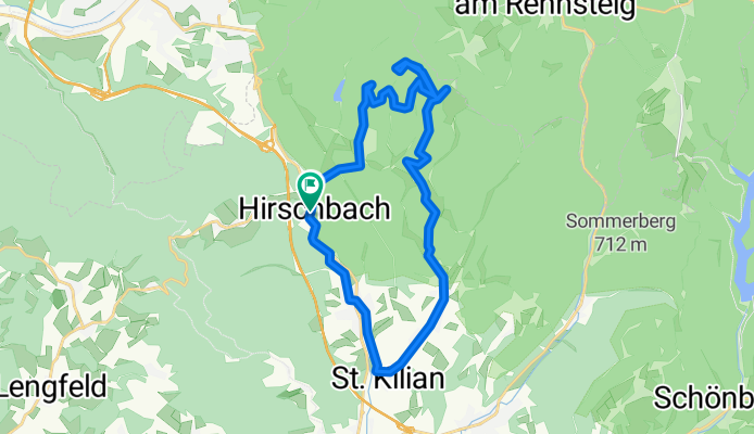
Hirschbach Atlersberg Breitenbach St.Kilian Hirschbach
A cycling route starting in Sankt Kilian, Thuringia, Germany.
Overview
About this route
<table border="0"> <tbody> <tr> <td>Stoppuhr:</td> <td>02:18:44</td> </tr> <tr> <td>Strecke:</td> <td>23.5 km</td> </tr> <tr> <td>Kalorien:</td> <td>2681 kcal</td> </tr> <tr> <td>Mittlere Geschw.:</td> <td>10.2 km/h</td> </tr> <tr> <td>Maximale Geschw.:</td> <td>43.0 km/h</td> </tr> <tr> <td>Höhenmeter:</td> <td>497 m</td> </tr> </tbody> </table>
- -:--
- Duration
- 24.3 km
- Distance
- 456 m
- Ascent
- 458 m
- Descent
- ---
- Avg. speed
- ---
- Max. altitude

Continue with Bikemap
Use, edit, or download this cycling route
You would like to ride Hirschbach Atlersberg Breitenbach St.Kilian Hirschbach or customize it for your own trip? Here is what you can do with this Bikemap route:
Free features
- Save this route as favorite or in collections
- Copy & plan your own version of this route
- Sync your route with Garmin or Wahoo
Premium features
Free trial for 3 days, or one-time payment. More about Bikemap Premium.
- Navigate this route on iOS & Android
- Export a GPX / KML file of this route
- Create your custom printout (try it for free)
- Download this route for offline navigation
Discover more Premium features.
Get Bikemap PremiumFrom our community
Other popular routes starting in Sankt Kilian
 Hirschbach Friedberg Hirschbach
- Distance
- 12.1 km
- Ascent
- 260 m
- Descent
- 260 m
- Location
- Sankt Kilian, Thuringia, Germany
 von Hirschbach nach Breitenbach zum Blockhaus
- Distance
- 7.9 km
- Ascent
- 125 m
- Descent
- 84 m
- Location
- Sankt Kilian, Thuringia, Germany
 Dillstädt-Simmersberg-Werraquelle-Oelze-Kahlert-Frauenwald-St. Kilian-Suhl-Dillstädt (Teil 3)
- Distance
- 26.5 km
- Ascent
- 370 m
- Descent
- 375 m
- Location
- Sankt Kilian, Thuringia, Germany
 Hirschbach Atlersberg Breitenbach St.Kilian Hirschbach
- Distance
- 24.3 km
- Ascent
- 456 m
- Descent
- 458 m
- Location
- Sankt Kilian, Thuringia, Germany
 von Hirschbach nach Zella-Mehlis und zurück
- Distance
- 48.3 km
- Ascent
- 885 m
- Descent
- 884 m
- Location
- Sankt Kilian, Thuringia, Germany
 Hirschbach, Erletortalsperre, Suhl Friedberg zurück nach Hirschbach
- Distance
- 16.2 km
- Ascent
- 372 m
- Descent
- 370 m
- Location
- Sankt Kilian, Thuringia, Germany
 von Hirschbach nach Zella-Mehlis
- Distance
- 19.7 km
- Ascent
- 333 m
- Descent
- 312 m
- Location
- Sankt Kilian, Thuringia, Germany
 Sankt Kilian; Vessertal; Schmiedefeld; Schneekopf; Adlersberg
- Distance
- 49.9 km
- Ascent
- 857 m
- Descent
- 857 m
- Location
- Sankt Kilian, Thuringia, Germany
Open it in the app