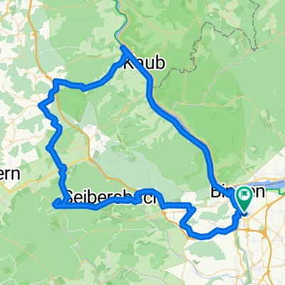
Salzkopf / Lauschhütte
A cycling route starting in Münster-Sarmsheim, Rhineland-Palatinate, Germany.
Overview
About this route
Schöne und abwechslungsreiche MTB-Tour zum Salzkopf, der höchsten Erhebung im Binger Wald (630müM). Von dort bieten sich tolle Weitblicke in Richtung Rheintal, Taunus und Hunsrück. An klaren Tagen sogar bis zur Hohen Acht in der Eifel.
Gefahren am 14.2.2009 bei voller Sonne, blauem Himmel, und größtenteils Schnee!
Viel Spaß u genau soviel Glück! :-) Jo_Montana
- -:--
- Duration
- 38.3 km
- Distance
- 789 m
- Ascent
- 660 m
- Descent
- ---
- Avg. speed
- 631 m
- Avg. speed
Route quality
Waytypes & surfaces along the route
Waytypes
Track
22.1 km
(58 %)
Quiet road
7.3 km
(19 %)
Surfaces
Paved
12.3 km
(32 %)
Unpaved
16.5 km
(43 %)
Gravel
12.2 km
(32 %)
Asphalt
9.1 km
(24 %)
Route highlights
Points of interest along the route
Point of interest after 21.8 km
Lauschhütte
Continue with Bikemap
Use, edit, or download this cycling route
You would like to ride Salzkopf / Lauschhütte or customize it for your own trip? Here is what you can do with this Bikemap route:
Free features
- Save this route as favorite or in collections
- Copy & plan your own version of this route
- Sync your route with Garmin or Wahoo
Premium features
Free trial for 3 days, or one-time payment. More about Bikemap Premium.
- Navigate this route on iOS & Android
- Export a GPX / KML file of this route
- Create your custom printout (try it for free)
- Download this route for offline navigation
Discover more Premium features.
Get Bikemap PremiumFrom our community
Other popular routes starting in Münster-Sarmsheim
- Route in Bingen am Rhein
- Distance
- 26.4 km
- Ascent
- 118 m
- Descent
- 115 m
- Location
- Münster-Sarmsheim, Rhineland-Palatinate, Germany
- Hochsteinchen-Kandrich
- Distance
- 57.5 km
- Ascent
- 1,094 m
- Descent
- 1,094 m
- Location
- Münster-Sarmsheim, Rhineland-Palatinate, Germany
- Bingen-Lauschhütte-Schanzerkopf-Stromberg-Heim
- Distance
- 73.5 km
- Ascent
- 1,353 m
- Descent
- 1,364 m
- Location
- Münster-Sarmsheim, Rhineland-Palatinate, Germany
- Kreuzbachklamm Tour
- Distance
- 40.1 km
- Ascent
- 1,161 m
- Descent
- 1,161 m
- Location
- Münster-Sarmsheim, Rhineland-Palatinate, Germany
- Soonwald-Bingerwald
- Distance
- 65.3 km
- Ascent
- 1,320 m
- Descent
- 1,041 m
- Location
- Münster-Sarmsheim, Rhineland-Palatinate, Germany
- Bingen-Kreuznach Salinental und zurück
- Distance
- 46.1 km
- Ascent
- 180 m
- Descent
- 180 m
- Location
- Münster-Sarmsheim, Rhineland-Palatinate, Germany
- Bikepark Stromberg mit eingebunden!
- Distance
- 61.7 km
- Ascent
- 1,185 m
- Descent
- 1,185 m
- Location
- Münster-Sarmsheim, Rhineland-Palatinate, Germany
- Salzkopf / Lauschhütte
- Distance
- 38.3 km
- Ascent
- 789 m
- Descent
- 660 m
- Location
- Münster-Sarmsheim, Rhineland-Palatinate, Germany
Open it in the app