
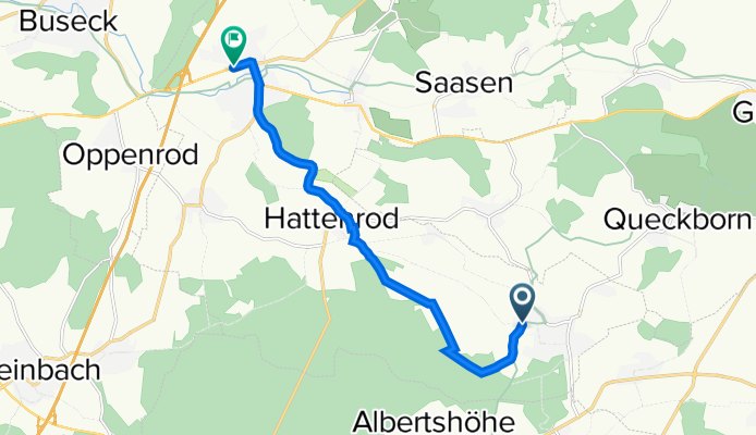
Licher Weg, Reiskirchen nach Grünberger Straße 4, Reiskirchen
A cycling route starting in Grünberg, Hesse, Germany.
Overview
About this route
- 31 min
- Duration
- 8.9 km
- Distance
- 80 m
- Ascent
- 61 m
- Descent
- 17.3 km/h
- Avg. speed
- 237 m
- Max. altitude
Route quality
Waytypes & surfaces along the route
Waytypes
Track
4.1 km
(46 %)
Busy road
2.5 km
(28 %)
Surfaces
Paved
5.5 km
(62 %)
Unpaved
1.4 km
(16 %)
Asphalt
5.5 km
(62 %)
Gravel
0.7 km
(8 %)
Continue with Bikemap
Use, edit, or download this cycling route
You would like to ride Licher Weg, Reiskirchen nach Grünberger Straße 4, Reiskirchen or customize it for your own trip? Here is what you can do with this Bikemap route:
Free features
- Save this route as favorite or in collections
- Copy & plan your own version of this route
- Sync your route with Garmin or Wahoo
Premium features
Free trial for 3 days, or one-time payment. More about Bikemap Premium.
- Navigate this route on iOS & Android
- Export a GPX / KML file of this route
- Create your custom printout (try it for free)
- Download this route for offline navigation
Discover more Premium features.
Get Bikemap PremiumFrom our community
Other popular routes starting in Grünberg
 Gießener Straße 1, Mücke nach Neupforte 20, Grünberg
- Distance
- 15.6 km
- Ascent
- 198 m
- Descent
- 209 m
- Location
- Grünberg, Hesse, Germany
 Sparkassen-Triathlon Grünberg
- Distance
- 5.5 km
- Ascent
- 113 m
- Descent
- 89 m
- Location
- Grünberg, Hesse, Germany
 Vogelsbergrundfahrt
- Distance
- 58.6 km
- Ascent
- 952 m
- Descent
- 982 m
- Location
- Grünberg, Hesse, Germany
 Mücker Hausrunde (NO-Rupp-Gr-E.-Sellnr. Lardenb. usw)
- Distance
- 23 km
- Ascent
- 111 m
- Descent
- 111 m
- Location
- Grünberg, Hesse, Germany
 Noch eine Vogelsbergrunde
- Distance
- 97.8 km
- Ascent
- 1,309 m
- Descent
- 1,309 m
- Location
- Grünberg, Hesse, Germany
 RSC Grünberg "Zum Schloß Romrod" permanent
- Distance
- 76.3 km
- Ascent
- 561 m
- Descent
- 561 m
- Location
- Grünberg, Hesse, Germany
 Am Tannenkopf 1, Grünberg nach Marktplatz 5, Grünberg
- Distance
- 51.2 km
- Ascent
- 748 m
- Descent
- 763 m
- Location
- Grünberg, Hesse, Germany
 Neuer Weg 30–34, Grünberg nach Atzenhainer Teich Neuer Weg 30, Grünberg
- Distance
- 8.8 km
- Ascent
- 36 m
- Descent
- 39 m
- Location
- Grünberg, Hesse, Germany
Open it in the app