9den_do Tramínu na ochutnávku
A cycling route starting in Caldaro sulla Strada del Vino, Trentino-Alto Adige, Italy.
Overview
About this route
- -:--
- Duration
- 15.2 km
- Distance
- 201 m
- Ascent
- 202 m
- Descent
- ---
- Avg. speed
- 286 m
- Max. altitude
Route quality
Waytypes & surfaces along the route
Waytypes
Quiet road
7.2 km
(47 %)
Track
1.7 km
(11 %)
Surfaces
Paved
11.9 km
(78 %)
Asphalt
11.4 km
(75 %)
Paved (undefined)
0.5 km
(3 %)
Undefined
3.4 km
(22 %)
Continue with Bikemap
Use, edit, or download this cycling route
You would like to ride 9den_do Tramínu na ochutnávku or customize it for your own trip? Here is what you can do with this Bikemap route:
Free features
- Save this route as favorite or in collections
- Copy & plan your own version of this route
- Sync your route with Garmin or Wahoo
Premium features
Free trial for 3 days, or one-time payment. More about Bikemap Premium.
- Navigate this route on iOS & Android
- Export a GPX / KML file of this route
- Create your custom printout (try it for free)
- Download this route for offline navigation
Discover more Premium features.
Get Bikemap PremiumFrom our community
Other popular routes starting in Caldaro sulla Strada del Vino
- Rund um den Berg von/nach Kaltern
- Distance
- 36.7 km
- Ascent
- 424 m
- Descent
- 578 m
- Location
- Caldaro sulla Strada del Vino, Trentino-Alto Adige, Italy
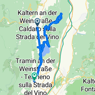
- 🚴♀️E*Bike🇮🇩 16.04.29. 4 Tag Weinstrasse - TRIENT
- Distance
- 52.7 km
- Ascent
- 292 m
- Descent
- 470 m
- Location
- Caldaro sulla Strada del Vino, Trentino-Alto Adige, Italy
- 🚴♀️E*Bike🇮🇩 Kaltern - Salurn - Leifers
- Distance
- 57.5 km
- Ascent
- 310 m
- Descent
- 469 m
- Location
- Caldaro sulla Strada del Vino, Trentino-Alto Adige, Italy
- Weintour 1: Tramin - Kurtatsch - Montan 5Winzer
- Distance
- 39.7 km
- Ascent
- 478 m
- Descent
- 477 m
- Location
- Caldaro sulla Strada del Vino, Trentino-Alto Adige, Italy
- Kaltern - Pressano - Cembra - Molina - Auer
- Distance
- 106 km
- Ascent
- 1,173 m
- Descent
- 1,160 m
- Location
- Caldaro sulla Strada del Vino, Trentino-Alto Adige, Italy
- Oberplanitzing - Medelpass - Gampenpass - Oberplanitzing
- Distance
- 71.1 km
- Ascent
- 2,117 m
- Descent
- 2,116 m
- Location
- Caldaro sulla Strada del Vino, Trentino-Alto Adige, Italy
- Grosses Steintal
- Distance
- 19 km
- Ascent
- 383 m
- Descent
- 383 m
- Location
- Caldaro sulla Strada del Vino, Trentino-Alto Adige, Italy
- Kaltern
- Distance
- 24 km
- Ascent
- 479 m
- Descent
- 479 m
- Location
- Caldaro sulla Strada del Vino, Trentino-Alto Adige, Italy
Open it in the app