

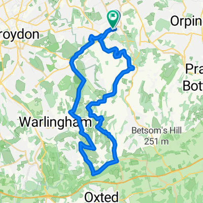
Botley Hill
A cycling route starting in West Wickham, England, United Kingdom.
Overview
About this route
- -:--
- Duration
- 30.7 km
- Distance
- 402 m
- Ascent
- 400 m
- Descent
- ---
- Avg. speed
- 263 m
- Max. altitude

Route quality
Waytypes & surfaces along the route
Waytypes
Road
13.2 km
(43 %)
Quiet road
9.8 km
(32 %)
Surfaces
Paved
12 km
(39 %)
Unpaved
4.6 km
(15 %)
Asphalt
12 km
(39 %)
Ground
3.7 km
(12 %)
Continue with Bikemap
Use, edit, or download this cycling route
You would like to ride Botley Hill or customize it for your own trip? Here is what you can do with this Bikemap route:
Free features
- Save this route as favorite or in collections
- Copy & plan your own version of this route
- Sync your route with Garmin or Wahoo
Premium features
Free trial for 3 days, or one-time payment. More about Bikemap Premium.
- Navigate this route on iOS & Android
- Export a GPX / KML file of this route
- Create your custom printout (try it for free)
- Download this route for offline navigation
Discover more Premium features.
Get Bikemap PremiumFrom our community
Other popular routes starting in West Wickham
 Addington to Merle Common
- Distance
- 33.5 km
- Ascent
- 353 m
- Descent
- 366 m
- Location
- West Wickham, England, United Kingdom
 test
test- Distance
- 38.4 km
- Ascent
- 401 m
- Descent
- 401 m
- Location
- West Wickham, England, United Kingdom
 Hayes station 37km
- Distance
- 37.2 km
- Ascent
- 412 m
- Descent
- 415 m
- Location
- West Wickham, England, United Kingdom
 New Addington Loop Through Warlingham and Woldingham
- Distance
- 27.5 km
- Ascent
- 283 m
- Descent
- 283 m
- Location
- West Wickham, England, United Kingdom
 Addington-Keston Loop
- Distance
- 13.9 km
- Ascent
- 147 m
- Descent
- 146 m
- Location
- West Wickham, England, United Kingdom
 New Addington Loop Past Botley Hill and Through Biggin Hill
- Distance
- 24.5 km
- Ascent
- 257 m
- Descent
- 247 m
- Location
- West Wickham, England, United Kingdom
 ahs sponsored walk
- Distance
- 14.4 km
- Ascent
- 205 m
- Descent
- 203 m
- Location
- West Wickham, England, United Kingdom
 LullingStone country park
- Distance
- 39.8 km
- Ascent
- 435 m
- Descent
- 437 m
- Location
- West Wickham, England, United Kingdom
Open it in the app