

Alhama-Cortijo Nacimientos-Robleda-Alama
A cycling route starting in Alhama de Granada, Andalusia, Spain.
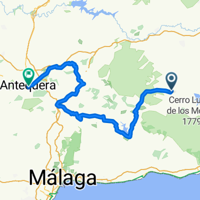
Overview
About this route
Wide track on almost the entire stretch, except for the first two kilometers which run along the Camino de los Ángeles (rough path, but impressive) and the kilometers between 14+000 and 18+500. In this last stretch, we find a kilometer (15+000-16+000) with a steep ramp (rideable for very few).
It is a quite attractive circuit due to its diversity of landscapes; Tajos de Alhama, diversion reservoir, natural park of Sierra de Alhama, etc.
- -:--
- Duration
- 29.4 km
- Distance
- 476 m
- Ascent
- 476 m
- Descent
- ---
- Avg. speed
- ---
- Max. altitude

Route quality
Waytypes & surfaces along the route
Waytypes
Quiet road
17.9 km
(61 %)
Track
9.1 km
(31 %)
Surfaces
Paved
2.4 km
(8 %)
Unpaved
13.2 km
(45 %)
Gravel
12.1 km
(41 %)
Asphalt
2.4 km
(8 %)
Continue with Bikemap
Use, edit, or download this cycling route
You would like to ride Alhama-Cortijo Nacimientos-Robleda-Alama or customize it for your own trip? Here is what you can do with this Bikemap route:
Free features
- Save this route as favorite or in collections
- Copy & plan your own version of this route
- Sync your route with Garmin or Wahoo
Premium features
Free trial for 3 days, or one-time payment. More about Bikemap Premium.
- Navigate this route on iOS & Android
- Export a GPX / KML file of this route
- Create your custom printout (try it for free)
- Download this route for offline navigation
Discover more Premium features.
Get Bikemap PremiumFrom our community
Other popular routes starting in Alhama de Granada
 ALHAMA-ALFARNATE-ALMENDRAL-ALHAMA
- Distance
- 73.4 km
- Ascent
- 1,066 m
- Descent
- 1,068 m
- Location
- Alhama de Granada, Andalusia, Spain
 Vuelta 2010 Tour 11
- Distance
- 52.6 km
- Ascent
- 663 m
- Descent
- 854 m
- Location
- Alhama de Granada, Andalusia, Spain
 Alhama - Viñuela - Archidona - Antequera
- Distance
- 116.4 km
- Ascent
- 1,332 m
- Descent
- 1,705 m
- Location
- Alhama de Granada, Andalusia, Spain
 AndenLucia 8k La Alcaiceria Málaga
- Distance
- 78.7 km
- Ascent
- 300 m
- Descent
- 1,282 m
- Location
- Alhama de Granada, Andalusia, Spain
 Spain Trip Day 4: Alhama de Granada-Malaga
- Distance
- 76.9 km
- Ascent
- 952 m
- Descent
- 1,822 m
- Location
- Alhama de Granada, Andalusia, Spain
 Alhama de grandada - el morche
- Distance
- 61.2 km
- Ascent
- 990 m
- Descent
- 1,844 m
- Location
- Alhama de Granada, Andalusia, Spain
 Moraleda-Turro-Cacín-Alhama
- Distance
- 49.6 km
- Ascent
- 704 m
- Descent
- 704 m
- Location
- Alhama de Granada, Andalusia, Spain
 Von Alhama de Granada nach Granada
- Distance
- 66.5 km
- Ascent
- 430 m
- Descent
- 637 m
- Location
- Alhama de Granada, Andalusia, Spain
Open it in the app