

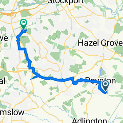
8 Burton Dr, Stockport to Pinfold Lane, Manchester
A cycling route starting in Poynton, England, United Kingdom.
Overview
About this route
- 1 h 10 min
- Duration
- 15.6 km
- Distance
- 30 m
- Ascent
- 52 m
- Descent
- 13.5 km/h
- Avg. speed
- 98 m
- Max. altitude
Route quality
Waytypes & surfaces along the route
Waytypes
Cycleway
8.1 km
(52 %)
Quiet road
3 km
(19 %)
Surfaces
Paved
10.2 km
(65 %)
Asphalt
8.6 km
(55 %)
Paved (undefined)
1.6 km
(10 %)
Undefined
5.5 km
(35 %)
Continue with Bikemap
Use, edit, or download this cycling route
You would like to ride 8 Burton Dr, Stockport to Pinfold Lane, Manchester or customize it for your own trip? Here is what you can do with this Bikemap route:
Free features
- Save this route as favorite or in collections
- Copy & plan your own version of this route
- Sync your route with Garmin or Wahoo
Premium features
Free trial for 3 days, or one-time payment. More about Bikemap Premium.
- Navigate this route on iOS & Android
- Export a GPX / KML file of this route
- Create your custom printout (try it for free)
- Download this route for offline navigation
Discover more Premium features.
Get Bikemap PremiumFrom our community
Other popular routes starting in Poynton
 32 Zest 2
- Distance
- 32.1 km
- Ascent
- 573 m
- Descent
- 573 m
- Location
- Poynton, England, United Kingdom
 25 Chester Road, Stockport to 84 Knutsford Road, Alderley Edge
- Distance
- 14.3 km
- Ascent
- 63 m
- Descent
- 80 m
- Location
- Poynton, England, United Kingdom
 175 Dickens Lane, Stockport to Brookfield House, Wilmslow Road, Cheadle
- Distance
- 13.2 km
- Ascent
- 11 m
- Descent
- 69 m
- Location
- Poynton, England, United Kingdom
 65–67 Shrigley Road S, Poynton, Stockport to 25 Chester Road, Stockport
- Distance
- 3.5 km
- Ascent
- 3 m
- Descent
- 58 m
- Location
- Poynton, England, United Kingdom
 Secret ways to Jodrell Copy
- Distance
- 64.1 km
- Ascent
- 281 m
- Descent
- 280 m
- Location
- Poynton, England, United Kingdom
 Llanfairpwllgwyngyllgogerychwyrndrobwyll-llantysiliogogogoch 1
- Distance
- 403.4 km
- Ascent
- 605 m
- Descent
- 605 m
- Location
- Poynton, England, United Kingdom
 Buxton & Cat & Fiddle
- Distance
- 53.3 km
- Ascent
- 681 m
- Descent
- 681 m
- Location
- Poynton, England, United Kingdom
 gawsworth/siddington
- Distance
- 72.3 km
- Ascent
- 182 m
- Descent
- 182 m
- Location
- Poynton, England, United Kingdom
Open it in the app