

TEST BIKEMAP
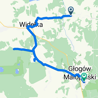
A cycling route starting in Raniżów, Subcarpathian Voivodeship, Poland.
Overview
About this route
- -:--
- Duration
- 2 km
- Distance
- 8 m
- Ascent
- 12 m
- Descent
- ---
- Avg. speed
- 210 m
- Max. altitude

Route quality
Waytypes & surfaces along the route
Waytypes
Road
2 km
(100 %)
Surfaces
Paved
2 km
(100 %)
Asphalt
2 km
(100 %)
Route highlights
Points of interest along the route
Point of interest after 0.6 km
STACJA
Continue with Bikemap
Use, edit, or download this cycling route
You would like to ride TEST BIKEMAP or customize it for your own trip? Here is what you can do with this Bikemap route:
Free features
- Save this route as favorite or in collections
- Copy & plan your own version of this route
- Sync your route with Garmin or Wahoo
Premium features
Free trial for 3 days, or one-time payment. More about Bikemap Premium.
- Navigate this route on iOS & Android
- Export a GPX / KML file of this route
- Create your custom printout (try it for free)
- Download this route for offline navigation
Discover more Premium features.
Get Bikemap PremiumFrom our community
Other popular routes starting in Raniżów
 rajd parafialny 1
- Distance
- 23.5 km
- Ascent
- 85 m
- Descent
- 87 m
- Location
- Raniżów, Subcarpathian Voivodeship, Poland
 Pielgrzymka rowerowa do Leżajska
- Distance
- 77.7 km
- Ascent
- 318 m
- Descent
- 318 m
- Location
- Raniżów, Subcarpathian Voivodeship, Poland
 Wola Raniżowska 366, Wola Raniżowska do Wola Raniżowska 366, Wola Raniżowska
- Distance
- 29.3 km
- Ascent
- 188 m
- Descent
- 187 m
- Location
- Raniżów, Subcarpathian Voivodeship, Poland
 TEST BIKEMAP
- Distance
- 2 km
- Ascent
- 8 m
- Descent
- 12 m
- Location
- Raniżów, Subcarpathian Voivodeship, Poland
 Przewrotne do ks. Forysiewicza
- Distance
- 24.2 km
- Ascent
- 106 m
- Descent
- 116 m
- Location
- Raniżów, Subcarpathian Voivodeship, Poland
 Wycieczka 23-06-2016
- Distance
- 55.7 km
- Ascent
- 188 m
- Descent
- 188 m
- Location
- Raniżów, Subcarpathian Voivodeship, Poland
 50.290° N 21.968° W do 50.268° N 21.855° W
- Distance
- 18.8 km
- Ascent
- 165 m
- Descent
- 157 m
- Location
- Raniżów, Subcarpathian Voivodeship, Poland
 Leżajsk
- Distance
- 76.7 km
- Ascent
- 291 m
- Descent
- 291 m
- Location
- Raniżów, Subcarpathian Voivodeship, Poland
Open it in the app