

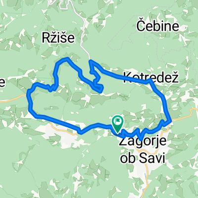
Pot iz Podvin do Zavin in nazaj
A cycling route starting in Zagorje ob Savi, Zagorje ob Savi Municipality, Slovenia.
Overview
About this route
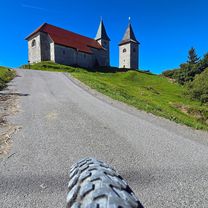
We can start in Podvin, where there is enough space to park the car and then set out on the route. We start the route in Podvin and then continue towards Zagorje for a while on the flat, so we can warm up a bit. I also find the climb from this side much easier than from Spodnie Izlak. Somewhere in the middle of the way we can also have a snack at the Hunting House in Klančišah. THE ROUTE IS CIRCULAR!!!
- -:--
- Duration
- 16 km
- Distance
- 397 m
- Ascent
- 397 m
- Descent
- ---
- Avg. speed
- ---
- Max. altitude
Route quality
Waytypes & surfaces along the route
Waytypes
Quiet road
6.3 km
(39 %)
Road
3.4 km
(21 %)
Surfaces
Paved
5 km
(31 %)
Unpaved
0.5 km
(3 %)
Asphalt
5 km
(31 %)
Ground
0.5 km
(3 %)
Undefined
10.6 km
(66 %)
Route highlights
Points of interest along the route
Point of interest after 8.5 km
Lovski dom Klančiše, Roman Žerko s.p.
Point of interest after 16 km
Začetna točka.
Continue with Bikemap
Use, edit, or download this cycling route
You would like to ride Pot iz Podvin do Zavin in nazaj or customize it for your own trip? Here is what you can do with this Bikemap route:
Free features
- Save this route as favorite or in collections
- Copy & plan your own version of this route
- Sync your route with Garmin or Wahoo
Premium features
Free trial for 3 days, or one-time payment. More about Bikemap Premium.
- Navigate this route on iOS & Android
- Export a GPX / KML file of this route
- Create your custom printout (try it for free)
- Download this route for offline navigation
Discover more Premium features.
Get Bikemap PremiumFrom our community
Other popular routes starting in Zagorje ob Savi
 Zagorje ob Savi - Lisca - Sevnica - Zagornje ob Savi
- Distance
- 92.5 km
- Ascent
- 1,247 m
- Descent
- 1,249 m
- Location
- Zagorje ob Savi, Zagorje ob Savi Municipality, Slovenia
 na kum
- Distance
- 9.6 km
- Ascent
- 1,007 m
- Descent
- 12 m
- Location
- Zagorje ob Savi, Zagorje ob Savi Municipality, Slovenia
 Kum, zasavski Triglav MTB
- Distance
- 43.9 km
- Ascent
- 1,776 m
- Descent
- 1,777 m
- Location
- Zagorje ob Savi, Zagorje ob Savi Municipality, Slovenia
 PLESKO
- Distance
- 5.2 km
- Ascent
- 261 m
- Descent
- 61 m
- Location
- Zagorje ob Savi, Zagorje ob Savi Municipality, Slovenia
 Kum iz Zagorja
- Distance
- 54.1 km
- Ascent
- 1,170 m
- Descent
- 1,170 m
- Location
- Zagorje ob Savi, Zagorje ob Savi Municipality, Slovenia
 Zagorje-Kal-Sava-Vače-Zagorje
- Distance
- 40.9 km
- Ascent
- 885 m
- Descent
- 885 m
- Location
- Zagorje ob Savi, Zagorje ob Savi Municipality, Slovenia
 Kumlansk kriterij
- Distance
- 48.5 km
- Ascent
- 642 m
- Descent
- 644 m
- Location
- Zagorje ob Savi, Zagorje ob Savi Municipality, Slovenia
 Gamberk
- Distance
- 15.6 km
- Ascent
- 405 m
- Descent
- 403 m
- Location
- Zagorje ob Savi, Zagorje ob Savi Municipality, Slovenia
Open it in the app