Hauenstein - Teufelsschlucht - Longbridge

A cycling route starting in Ormalingen, Basel-Landschaft, Switzerland.

Overview

About this route

0

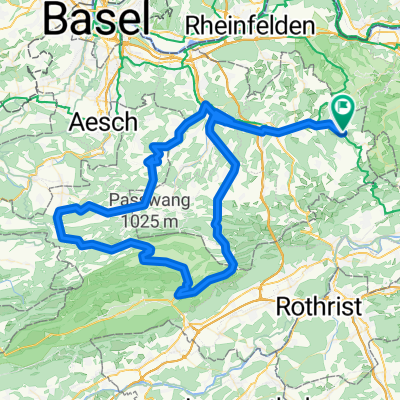
After a light warm-up of 12 km, it starts from Buckten with a gentle incline up to the Hauenstein pass height (683 m above sea level). After the descent to Olten, the approach to Gäu begins. In Hägendorf, turn right at the roundabout and the somewhat steeper climb starts already in the village. Above the village, at the edge of the forest, there's a wonderful view of the Alps with Eiger, Mönch, and Jungfrau (the view on 28.08.2011 was fantastic). Further ascent up to Bärenwil. From there, it descends for about 10 kilometers via Langenbruck (with a short climb in the village) down through Waldenburg until the valley floor is reached at Hölstein. Via Liestal back to Oberbaselbiet.

Translated, show original (German)
-:--
Duration
72.3 km
Distance
776 m
Ascent
783 m
Descent
---
Avg. speed
---
Max. altitude
menne on ct2
menne on ct2

created this 14 years ago

Route quality

Waytypes & surfaces along the route

Continue with Bikemap

Use, edit, or download this cycling route

You would like to ride Hauenstein - Teufelsschlucht - Longbridge or customize it for your own trip? Here is what you can do with this Bikemap route:

Free features

Premium features

Free trial for 3 days, or one-time payment. More about Bikemap Premium.

  • Navigate this route on iOS & Android
  • Export a GPX / KML file of this route
  • Create your custom printout (try it for free)
  • Download this route for offline navigation

Discover more Premium features.

Get Bikemap Premium

From our community

Other popular routes starting in Ormalingen

Open it in the app