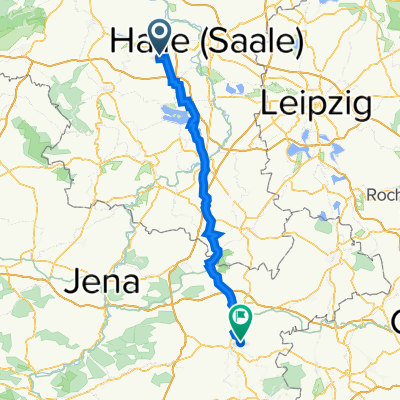
T-thal-Luckenau
A cycling route starting in Teutschenthal, Saxony-Anhalt, Germany.
Overview
About this route
- -:--
- Duration
- 55.5 km
- Distance
- 331 m
- Ascent
- 279 m
- Descent
- ---
- Avg. speed
- 207 m
- Avg. speed
Route quality
Waytypes & surfaces along the route
Waytypes
Quiet road
16.3 km
(29 %)
Road
14.7 km
(27 %)
Surfaces
Paved
49 km
(88 %)
Unpaved
0.3 km
(<1 %)
Asphalt
46.8 km
(84 %)
Concrete
1.6 km
(3 %)
Continue with Bikemap
Use, edit, or download this cycling route
You would like to ride T-thal-Luckenau or customize it for your own trip? Here is what you can do with this Bikemap route:
Free features
- Save this route as favorite or in collections
- Copy & plan your own version of this route
- Sync your route with Garmin or Wahoo
Premium features
Free trial for 3 days, or one-time payment. More about Bikemap Premium.
- Navigate this route on iOS & Android
- Export a GPX / KML file of this route
- Create your custom printout (try it for free)
- Download this route for offline navigation
Discover more Premium features.
Get Bikemap PremiumFrom our community
Other popular routes starting in Teutschenthal
- R_5_TThal-Konstanz
- Distance
- 598.2 km
- Ascent
- 3,309 m
- Descent
- 3,025 m
- Location
- Teutschenthal, Saxony-Anhalt, Germany
- T-thal-Luckenau
- Distance
- 55.5 km
- Ascent
- 331 m
- Descent
- 279 m
- Location
- Teutschenthal, Saxony-Anhalt, Germany
- t-tal- wittmar
- Distance
- 132.2 km
- Ascent
- 756 m
- Descent
- 746 m
- Location
- Teutschenthal, Saxony-Anhalt, Germany
- Route_1_Tthal_Bad S
- Distance
- 86.2 km
- Ascent
- 346 m
- Descent
- 368 m
- Location
- Teutschenthal, Saxony-Anhalt, Germany
- TESTROUTE 2014
- Distance
- 14.8 km
- Ascent
- 108 m
- Descent
- 122 m
- Location
- Teutschenthal, Saxony-Anhalt, Germany
- Tthal-Eurokultern
- Distance
- 21.7 km
- Ascent
- 140 m
- Descent
- 65 m
- Location
- Teutschenthal, Saxony-Anhalt, Germany
- Route_7_T_thal - Mücheln_Marina
- Distance
- 19.7 km
- Ascent
- 71 m
- Descent
- 92 m
- Location
- Teutschenthal, Saxony-Anhalt, Germany
- Feldstraße 18, Teutschenthal nach Kurze Straße 6, Braunsbedra
- Distance
- 28.2 km
- Ascent
- 133 m
- Descent
- 131 m
- Location
- Teutschenthal, Saxony-Anhalt, Germany
Open it in the app