
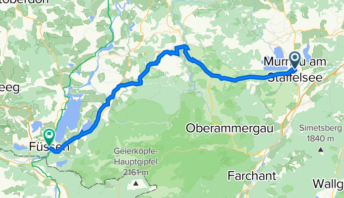
Murnau-Füssen
A cycling route starting in Murnau am Staffelsee, Bavaria, Germany.
Overview
About this route
- -:--
- Duration
- 53.5 km
- Distance
- 748 m
- Ascent
- 641 m
- Descent
- ---
- Avg. speed
- 889 m
- Max. altitude
Route quality
Waytypes & surfaces along the route
Waytypes
Quiet road
21.5 km
(40 %)
Path
13.1 km
(25 %)
Surfaces
Paved
51.9 km
(97 %)
Unpaved
0.8 km
(2 %)
Asphalt
51.4 km
(96 %)
Unpaved (undefined)
0.5 km
(1 %)
Continue with Bikemap
Use, edit, or download this cycling route
You would like to ride Murnau-Füssen or customize it for your own trip? Here is what you can do with this Bikemap route:
Free features
- Save this route as favorite or in collections
- Copy & plan your own version of this route
- Sync your route with Garmin or Wahoo
Premium features
Free trial for 3 days, or one-time payment. More about Bikemap Premium.
- Navigate this route on iOS & Android
- Export a GPX / KML file of this route
- Create your custom printout (try it for free)
- Download this route for offline navigation
Discover more Premium features.
Get Bikemap PremiumFrom our community
Other popular routes starting in Murnau am Staffelsee
 Osterseenrunde
- Distance
- 43 km
- Ascent
- 354 m
- Descent
- 354 m
- Location
- Murnau am Staffelsee, Bavaria, Germany
 Kleine Murnaurunde
- Distance
- 68.5 km
- Ascent
- 348 m
- Descent
- 340 m
- Location
- Murnau am Staffelsee, Bavaria, Germany
 3-Seen-Runde ( Staffel-, Froschhauser-, Riegsee )
- Distance
- 34.5 km
- Ascent
- 102 m
- Descent
- 102 m
- Location
- Murnau am Staffelsee, Bavaria, Germany
 Murnau - Oberammergau - Kloster Ettal
- Distance
- 56.6 km
- Ascent
- 429 m
- Descent
- 429 m
- Location
- Murnau am Staffelsee, Bavaria, Germany
 Staffelsee-Runde
- Distance
- 44.3 km
- Ascent
- 399 m
- Descent
- 399 m
- Location
- Murnau am Staffelsee, Bavaria, Germany
 Staffelsee und Riegsee
- Distance
- 29.4 km
- Ascent
- 225 m
- Descent
- 222 m
- Location
- Murnau am Staffelsee, Bavaria, Germany
 Murnauer Moos
- Distance
- 25.5 km
- Ascent
- 140 m
- Descent
- 141 m
- Location
- Murnau am Staffelsee, Bavaria, Germany
 Ohlstadt, rund um Herzogstand, Walchensee,Eschelainethal
- Distance
- 60.1 km
- Ascent
- 929 m
- Descent
- 929 m
- Location
- Murnau am Staffelsee, Bavaria, Germany
Open it in the app