

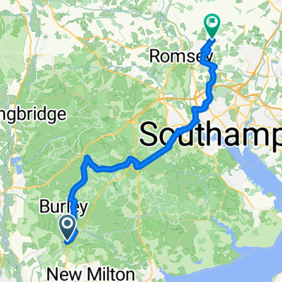
Wotton Bolder Wood Burly Loop
A cycling route starting in Bransgore, England, United Kingdom.
Overview
About this route
- -:--
- Duration
- 34.2 km
- Distance
- 322 m
- Ascent
- 323 m
- Descent
- ---
- Avg. speed
- 71 m
- Max. altitude
Steve Lee
created this 3 years ago
Route quality
Waytypes & surfaces along the route
Waytypes
Track
13 km
(38 %)
Quiet road
8.5 km
(25 %)
Surfaces
Paved
13 km
(38 %)
Unpaved
18.5 km
(54 %)
Gravel
18.5 km
(54 %)
Asphalt
12.3 km
(36 %)
Continue with Bikemap
Use, edit, or download this cycling route
You would like to ride Wotton Bolder Wood Burly Loop or customize it for your own trip? Here is what you can do with this Bikemap route:
Free features
- Save this route as favorite or in collections
- Copy & plan your own version of this route
- Sync your route with Garmin or Wahoo
Premium features
Free trial for 3 days, or one-time payment. More about Bikemap Premium.
- Navigate this route on iOS & Android
- Export a GPX / KML file of this route
- Create your custom printout (try it for free)
- Download this route for offline navigation
Discover more Premium features.
Get Bikemap PremiumFrom our community
Other popular routes starting in Bransgore
- Avon Tyrell - Bouderwood - Lyndhurst Loop
- 43.6 km
- 457 m
- 455 m
- Bransgore, England, United Kingdom
- Holmsley Campsite, Christchurch to Ampfield Hill, Romsey
- 45.9 km
- 312 m
- 321 m
- Bransgore, England, United Kingdom
- woods corner car park
- 10.4 km
- 85 m
- 85 m
- Bransgore, England, United Kingdom
- Burley The Hill Fort
- 13.5 km
- 117 m
- 116 m
- Bransgore, England, United Kingdom
- Holmsley Passage, Burley to Stonehenge Road 3, Amesbury
- 55.9 km
- 417 m
- 363 m
- Bransgore, England, United Kingdom
- burley
- 18.3 km
- 0 m
- 8 m
- Bransgore, England, United Kingdom
- Recovered Route
- 362.3 km
- 13 m
- 33 m
- Bransgore, England, United Kingdom


Open it in the app