

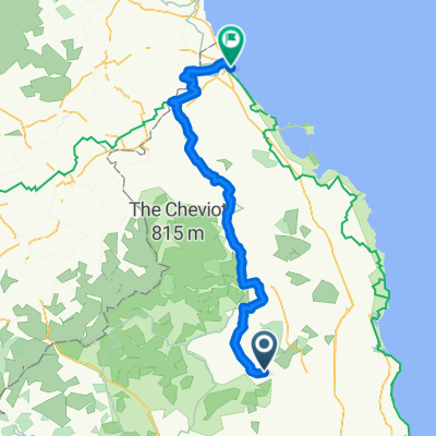
Rothbury - Bellingham - Elsdon - Rothbury
A cycling route starting in Rothbury, England, United Kingdom.
Overview
About this route
Start at the car park on the south side of the river in Rothbury.
This route takes you through the pleasant villages of Bellingham and Elsdon.
Hilly throughout .
- -:--
- Duration
- 77.5 km
- Distance
- 732 m
- Ascent
- 733 m
- Descent
- ---
- Avg. speed
- ---
- Max. altitude
Route quality
Waytypes & surfaces along the route
Waytypes
Busy road
52.8 km
(68 %)
Quiet road
22.4 km
(29 %)
Surfaces
Paved
10.3 km
(13 %)
Asphalt
10.3 km
(13 %)
Undefined
67.2 km
(87 %)
Continue with Bikemap
Use, edit, or download this cycling route
You would like to ride Rothbury - Bellingham - Elsdon - Rothbury or customize it for your own trip? Here is what you can do with this Bikemap route:
Free features
- Save this route as favorite or in collections
- Copy & plan your own version of this route
- Sync your route with Garmin or Wahoo
Premium features
Free trial for 3 days, or one-time payment. More about Bikemap Premium.
- Navigate this route on iOS & Android
- Export a GPX / KML file of this route
- Create your custom printout (try it for free)
- Download this route for offline navigation
Discover more Premium features.
Get Bikemap PremiumFrom our community
Other popular routes starting in Rothbury
 Unnamed Road to Woodhall Farm
- Distance
- 113.1 km
- Ascent
- 2,241 m
- Descent
- 2,239 m
- Location
- Rothbury, England, United Kingdom
 Rothbury - Bellingham - Elsdon - Rothbury
- Distance
- 77.5 km
- Ascent
- 732 m
- Descent
- 733 m
- Location
- Rothbury, England, United Kingdom
 Rothbury-Elsdon
- Distance
- 89.5 km
- Ascent
- 905 m
- Descent
- 905 m
- Location
- Rothbury, England, United Kingdom
 Bridge Street 15, Rothbury to B6341
- Distance
- 13 km
- Ascent
- 401 m
- Descent
- 304 m
- Location
- Rothbury, England, United Kingdom
 rothbury to berwick
- Distance
- 83.8 km
- Ascent
- 416 m
- Descent
- 485 m
- Location
- Rothbury, England, United Kingdom
 Cragside to Eastfield Hall
- Distance
- 69.6 km
- Ascent
- 546 m
- Descent
- 687 m
- Location
- Rothbury, England, United Kingdom
 day 4
day 4- Distance
- 85 km
- Ascent
- 402 m
- Descent
- 478 m
- Location
- Rothbury, England, United Kingdom
 rothbury route
- Distance
- 7.4 km
- Ascent
- 137 m
- Descent
- 137 m
- Location
- Rothbury, England, United Kingdom
Open it in the app