

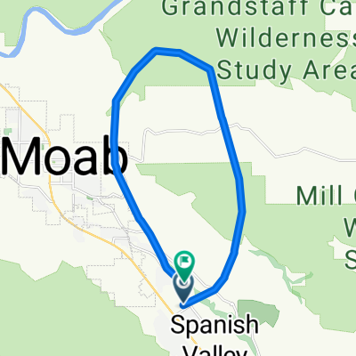
Moab through Arches and Back
A cycling route starting in Moab, Utah, United States.
Overview
About this route
This is simply one of the finest road bike rides in the world. At just under 44 miles, you gain and loose 3300 ft (1000 meters) through one of Americas most beautiful national parks. There is no bike lane so simply ride along the side of the road and make the drivers be aware of you. Take plenty of water and get an early start in the summer months. Gaining this much altitude means you need to be ready for a change in temps in spring and fall. Winter would be pretty cold, but really warm dry days are possible. There is water at Devils Garden, the high point and far end, and there is water at the Park HQ about 4 miles into the ride. Pick up the bike path along the highway when you leave and go into the Park. There is a fee for entering the Park (not sure what it is). If you are a visitor and need a bike try Poison Spider on the north end of Moab.
- -:--
- Duration
- 69.8 km
- Distance
- 1,017 m
- Ascent
- 1,024 m
- Descent
- ---
- Avg. speed
- ---
- Max. altitude
Route quality
Waytypes & surfaces along the route
Waytypes
Road
18.9 km
(27 %)
Cycleway
11.9 km
(17 %)
Surfaces
Paved
69.1 km
(99 %)
Asphalt
67 km
(96 %)
Paved (undefined)
2.1 km
(3 %)
Undefined
0.7 km
(1 %)
Continue with Bikemap
Use, edit, or download this cycling route
You would like to ride Moab through Arches and Back or customize it for your own trip? Here is what you can do with this Bikemap route:
Free features
- Save this route as favorite or in collections
- Copy & plan your own version of this route
- Sync your route with Garmin or Wahoo
Premium features
Free trial for 3 days, or one-time payment. More about Bikemap Premium.
- Navigate this route on iOS & Android
- Export a GPX / KML file of this route
- Create your custom printout (try it for free)
- Download this route for offline navigation
Discover more Premium features.
Get Bikemap PremiumFrom our community
Other popular routes starting in Moab
 Moab to Mineral Bottom Road
- Distance
- 75.4 km
- Ascent
- 688 m
- Descent
- 690 m
- Location
- Moab, Utah, United States
 Porcupine Rim Trail
- Distance
- 22.9 km
- Ascent
- 529 m
- Descent
- 1,054 m
- Location
- Moab, Utah, United States
 Moab
Moab- Distance
- 17.3 km
- Ascent
- 691 m
- Descent
- 708 m
- Location
- Moab, Utah, United States
 Moab 100
- Distance
- 159.6 km
- Ascent
- 957 m
- Descent
- 957 m
- Location
- Moab, Utah, United States
 Portal Long Canyon Mag7 Portal
- Distance
- 72.7 km
- Ascent
- 1,754 m
- Descent
- 1,750 m
- Location
- Moab, Utah, United States
 Moab Gran Fondo Loop
- Distance
- 94.5 km
- Ascent
- 1,824 m
- Descent
- 1,675 m
- Location
- Moab, Utah, United States
 Moab - A Pretty Flat Route to Potash
- Distance
- 66.2 km
- Ascent
- 1,097 m
- Descent
- 1,092 m
- Location
- Moab, Utah, United States
 Moab - Runde
- Distance
- 76.8 km
- Ascent
- 1,470 m
- Descent
- 1,484 m
- Location
- Moab, Utah, United States
Open it in the app