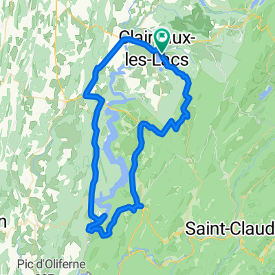
Route 3 RL
- 72.3 km
- 918 m
- 915 m
- Clairvaux-les-Lacs, Bourgogne-Franche-Comté, France
A cycling route starting in Clairvaux-les-Lacs, Bourgogne-Franche-Comté, France.
Overview
The French Jura is a diagonal mountain range with several rows of ridges. You can ride well along the valleys, but sometimes you go over them. This route starts steeply from the campsite Domaine de Chalain (by the lake of the same name; at an altitude of 500 meters) to take you through quiet roads and sparsely populated areas into alpine-like valleys. In Chaux-Neuve, it is about 1100 meters and clearly a ski area. It offers nice views of the Jura mountains in the distance. From Chaux-Neuve, the climb goes up to 1400 meters towards Chapelle-de-Bois. You find yourself in an abandoned valley where it can be a bit cooler than in the others. It is the last valley against the Swiss border. In the descent to Morez, you pass by the famous viaducts of the Ligne des Hirondelles. From here it is a tough climb to Col de Savine to then be able to reach high speeds downhill amidst the heavy traffic.
Route quality
Road
23.1 km
(26 %)
Quiet road
5.3 km
(6 %)
Paved
63.9 km
(72 %)
Unpaved
0.9 km
(1 %)
Asphalt
63.9 km
(72 %)
Gravel
0.9 km
(1 %)
Undefined
24 km
(27 %)
Continue with Bikemap
You would like to ride Fr: Haute Jura or customize it for your own trip? Here is what you can do with this Bikemap route:
Free trial for 3 days, or one-time payment. More about Bikemap Premium.
Discover more Premium features.
Get Bikemap PremiumFrom our community
Open it in the app