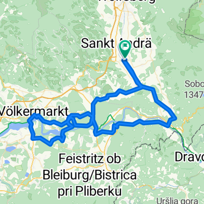
Wolkersdorf-Reisbergerhütte- Pöllingerhütte-Pölling-Wolkersdorf
A cycling route starting in Sankt Andrä, Carinthia, Austria.
Overview
About this route
kurze tragepassage beim letzten stück vor der pöllingerhütte
- -:--
- Duration
- 41 km
- Distance
- 1,229 m
- Ascent
- 1,229 m
- Descent
- ---
- Avg. speed
- ---
- Avg. speed
Route quality
Waytypes & surfaces along the route
Waytypes
Quiet road
35 km
(85 %)
Track
4.5 km
(11 %)
Surfaces
Paved
0.8 km
(2 %)
Unpaved
8.3 km
(20 %)
Gravel
7.6 km
(19 %)
Unpaved (undefined)
0.7 km
(2 %)
Continue with Bikemap
Use, edit, or download this cycling route
You would like to ride Wolkersdorf-Reisbergerhütte- Pöllingerhütte-Pölling-Wolkersdorf or customize it for your own trip? Here is what you can do with this Bikemap route:
Free features
- Save this route as favorite or in collections
- Copy & plan your own version of this route
- Sync your route with Garmin or Wahoo
Premium features
Free trial for 3 days, or one-time payment. More about Bikemap Premium.
- Navigate this route on iOS & Android
- Export a GPX / KML file of this route
- Create your custom printout (try it for free)
- Download this route for offline navigation
Discover more Premium features.
Get Bikemap PremiumFrom our community
Other popular routes starting in Sankt Andrä
- Lavant_Drau_Vkmkt
- Distance
- 93.3 km
- Ascent
- 595 m
- Descent
- 593 m
- Location
- Sankt Andrä, Carinthia, Austria
- Speikkogel iz Maildorfa
- Distance
- 18.5 km
- Ascent
- 1,234 m
- Descent
- 182 m
- Location
- Sankt Andrä, Carinthia, Austria
- St.Andrä - Bad St.Leonhardt - Wolfsberg -St.Andrä
- Distance
- 58.1 km
- Ascent
- 547 m
- Descent
- 559 m
- Location
- Sankt Andrä, Carinthia, Austria
- Griffner Runde
- Distance
- 48.3 km
- Ascent
- 755 m
- Descent
- 754 m
- Location
- Sankt Andrä, Carinthia, Austria
- 70.3 Triathlon Intern Laufstrecke Teil 1
- Distance
- 7.6 km
- Ascent
- 12 m
- Descent
- 12 m
- Location
- Sankt Andrä, Carinthia, Austria
- Wolkersdorf-Reisbergerhütte- Pöllingerhütte-Pölling-Wolkersdorf
- Distance
- 41 km
- Ascent
- 1,229 m
- Descent
- 1,229 m
- Location
- Sankt Andrä, Carinthia, Austria
- Leiwald-Klippitztörltour
- Distance
- 66.4 km
- Ascent
- 1,508 m
- Descent
- 1,506 m
- Location
- Sankt Andrä, Carinthia, Austria
- MTB-Tour über Diex
- Distance
- 79 km
- Ascent
- 1,918 m
- Descent
- 1,918 m
- Location
- Sankt Andrä, Carinthia, Austria
Open it in the app