

Wein und Wald Riol
A cycling route starting in Longuich, Rhineland-Palatinate, Germany.
Overview
About this route
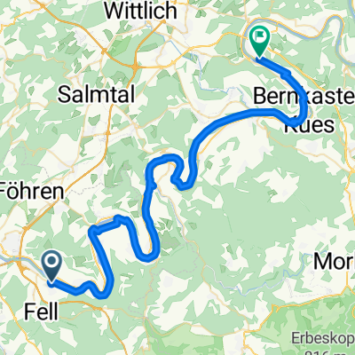
Start am Festplatz, Moselstr., Mühlenflur., an der Rioler Mühle vorbei rechts hoch Richtung Fastrauer Brücke, leichter Anstieg, neben der Autobahn durch die Weinberge am Schild Römerberg vorbei, Abfahrt zum Sauerborn, über den WeinErlebnisPfad Richtung Wald, kurzer steiler Anstieg, nach 100 m im Wald links in unbefestigten Weg rein, bis zur Rodelbahn, unter der Molesbachbrücke durch, Abfahrt am Klettersteig vorbei, rechts halten, weiter bis zum Schützenhaus in Mehring, weiter hinter den Häusern am Sportplatz vorbei zur Mosel, über Moselradweg und Seerundweg zurück.
- -:--
- Duration
- 11 km
- Distance
- 340 m
- Ascent
- 343 m
- Descent
- ---
- Avg. speed
- ---
- Max. altitude
Continue with Bikemap
Use, edit, or download this cycling route
You would like to ride Wein und Wald Riol or customize it for your own trip? Here is what you can do with this Bikemap route:
Free features
- Save this route as favorite or in collections
- Copy & plan your own version of this route
- Sync your route with Garmin or Wahoo
Premium features
Free trial for 3 days, or one-time payment. More about Bikemap Premium.
- Navigate this route on iOS & Android
- Export a GPX / KML file of this route
- Create your custom printout (try it for free)
- Download this route for offline navigation
Discover more Premium features.
Get Bikemap PremiumFrom our community
Other popular routes starting in Longuich
 MTB Tour
- Distance
- 18.3 km
- Ascent
- 386 m
- Descent
- 378 m
- Location
- Longuich, Rhineland-Palatinate, Germany
 Mittelmosel, moderat mit Schifffahrt
- Distance
- 51.4 km
- Ascent
- 202 m
- Descent
- 217 m
- Location
- Longuich, Rhineland-Palatinate, Germany
 4 Länder Tour
- Distance
- 189.5 km
- Ascent
- 679 m
- Descent
- 668 m
- Location
- Longuich, Rhineland-Palatinate, Germany
 Weinroute
- Distance
- 90.5 km
- Ascent
- 566 m
- Descent
- 573 m
- Location
- Longuich, Rhineland-Palatinate, Germany
 2016-2 Riol to Schweich railway station (Germany)
- Distance
- 8 km
- Ascent
- 62 m
- Descent
- 37 m
- Location
- Longuich, Rhineland-Palatinate, Germany
 Wein und Wald Riol
- Distance
- 11 km
- Ascent
- 287 m
- Descent
- 288 m
- Location
- Longuich, Rhineland-Palatinate, Germany
 Riol1
Riol1- Distance
- 67.3 km
- Ascent
- 1,053 m
- Descent
- 1,047 m
- Location
- Longuich, Rhineland-Palatinate, Germany
 Mosel 2
- Distance
- 52.7 km
- Ascent
- 93 m
- Descent
- 106 m
- Location
- Longuich, Rhineland-Palatinate, Germany
Open it in the app