
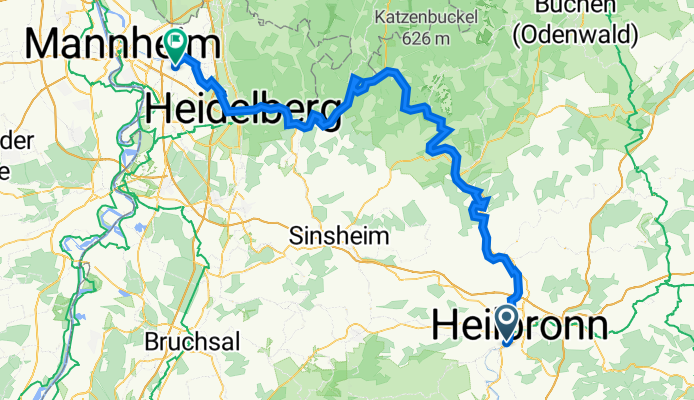
Heilbronn nach Ilvesheim dem Neckar entlang
A cycling route starting in Heilbronn, Baden-Württemberg, Germany.
Overview
About this route
- -:--
- Duration
- 109.2 km
- Distance
- 909 m
- Ascent
- 972 m
- Descent
- ---
- Avg. speed
- 184 m
- Max. altitude

Route quality
Waytypes & surfaces along the route
Waytypes
Track
36.6 km
(34 %)
Quiet road
23.1 km
(21 %)
Surfaces
Paved
97 km
(89 %)
Unpaved
11.5 km
(11 %)
Asphalt
89.8 km
(82 %)
Gravel
9.6 km
(9 %)
Route highlights
Points of interest along the route
Point of interest after 7.1 km
NSU-Museum
Point of interest after 7.3 km
Audi-Forum
Point of interest after 9.6 km
Salzbergwerk
Point of interest after 12.6 km
Spielplatz
Point of interest after 12.8 km
Spielplatz (evtl. geschlossen)
Point of interest after 13.1 km
Stiftskirche St. Peter
Point of interest after 14.5 km
Altstadt
Point of interest after 15.3 km
Spielplatz
Point of interest after 19.6 km
Schloss Horneck
Point of interest after 21.2 km
Burg Guttenberg
Point of interest after 27.6 km
Burg Hornberg
Point of interest after 33.7 km
Spielplatz
Point of interest after 33.8 km
Hotel-Gasthof Destille Eisenbahn Kantstr. 29 74821 Mosbach
Point of interest after 34.3 km
Aussichtspunkt
Point of interest after 36 km
Milchautomat
Point of interest after 37.2 km
Burg Dauchstein
Point of interest after 43.3 km
Margarethenschlucht
Point of interest after 43.5 km
Gickelfelsen Aussichtpunkt
Point of interest after 44 km
Spielplatz
Point of interest after 45.4 km
Spielplatz
Point of interest after 45.8 km
Minneburg
Point of interest after 49.4 km
Wolfsschlucht
Point of interest after 53.5 km
Burg Stolzeneck
Point of interest after 57.2 km
Spielplatz an der Kanone
Point of interest after 57.3 km
Spielplatz
Point of interest after 58 km
Höchster Baum im Odenwald und Spielplatz
Point of interest after 67.2 km
Kapelle und Aussichtpunkt
Point of interest after 68.1 km
Schloss Hirschhorn
Point of interest after 68.2 km
Burg Hirschhorn
Point of interest after 68.2 km
Hotel zur Krone Hauptstr. 35 69434 Hirschhorn
Point of interest after 78.2 km
Spielplatz
Point of interest after 78.3 km
Ruine Hinterburg
Point of interest after 78.6 km
Burg Schadeck
Point of interest after 81.3 km
Spielplatz
Point of interest after 86.8 km
Spielplatz
Point of interest after 89.1 km
Spongebob Stromkasten
Point of interest after 93.1 km
Neckarwiese
Continue with Bikemap
Use, edit, or download this cycling route
You would like to ride Heilbronn nach Ilvesheim dem Neckar entlang or customize it for your own trip? Here is what you can do with this Bikemap route:
Free features
- Save this route as favorite or in collections
- Copy & plan your own version of this route
- Split it into stages to create a multi-day tour
- Sync your route with Garmin or Wahoo
Premium features
Free trial for 3 days, or one-time payment. More about Bikemap Premium.
- Navigate this route on iOS & Android
- Export a GPX / KML file of this route
- Create your custom printout (try it for free)
- Download this route for offline navigation
Discover more Premium features.
Get Bikemap PremiumFrom our community
Other popular routes starting in Heilbronn
 Kocher-Jagst-Tour Teil 1
- Distance
- 99.3 km
- Ascent
- 826 m
- Descent
- 724 m
- Location
- Heilbronn, Baden-Württemberg, Germany
 Heilbronn - Geddelsbach - Dimbach - Heilbronn
- Distance
- 71.3 km
- Ascent
- 343 m
- Descent
- 328 m
- Location
- Heilbronn, Baden-Württemberg, Germany
 Heilbronn - Neckarwestheim - Böckingen - Heilbronn
- Distance
- 38 km
- Ascent
- 266 m
- Descent
- 265 m
- Location
- Heilbronn, Baden-Württemberg, Germany
 HN-Stettenfels-Donnbronn-HN
- Distance
- 23.2 km
- Ascent
- 282 m
- Descent
- 282 m
- Location
- Heilbronn, Baden-Württemberg, Germany
 Finale RSG Radrunde vor dem Mondseerennen am kommenden Wochenende...
- Distance
- 96.8 km
- Ascent
- 288 m
- Descent
- 289 m
- Location
- Heilbronn, Baden-Württemberg, Germany
 Drei Tälertour Neckar, Kocher Jagst, Neckar
- Distance
- 63.4 km
- Ascent
- 579 m
- Descent
- 608 m
- Location
- Heilbronn, Baden-Württemberg, Germany
 Neipperger Runde
- Distance
- 36.4 km
- Ascent
- 355 m
- Descent
- 353 m
- Location
- Heilbronn, Baden-Württemberg, Germany
 Öhr_jagsttal
- Distance
- 97.1 km
- Ascent
- 466 m
- Descent
- 472 m
- Location
- Heilbronn, Baden-Württemberg, Germany
Open it in the app