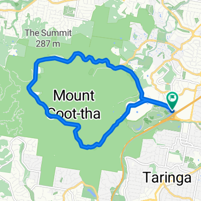
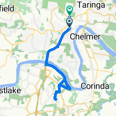
Western Brisbane 67 km River Loop
A cycling route starting in Taringa, Queensland, Australia.
Overview
About this route
- -:--
- Duration
- 67.3 km
- Distance
- 759 m
- Ascent
- 758 m
- Descent
- ---
- Avg. speed
- 63 m
- Max. altitude
Route quality
Waytypes & surfaces along the route
Waytypes
Cycleway
23.5 km
(35 %)
Quiet road
20.4 km
(30 %)
Surfaces
Paved
65.2 km
(97 %)
Unpaved
0 km
(<1 %)
Asphalt
44.3 km
(66 %)
Concrete
15.9 km
(24 %)
Continue with Bikemap
Use, edit, or download this cycling route
You would like to ride Western Brisbane 67 km River Loop or customize it for your own trip? Here is what you can do with this Bikemap route:
Free features
- Save this route as favorite or in collections
- Copy & plan your own version of this route
- Sync your route with Garmin or Wahoo
Premium features
Free trial for 3 days, or one-time payment. More about Bikemap Premium.
- Navigate this route on iOS & Android
- Export a GPX / KML file of this route
- Create your custom printout (try it for free)
- Download this route for offline navigation
Discover more Premium features.
Get Bikemap PremiumFrom our community
Other popular routes starting in Taringa
- Mt Cootha + riverloop
- Distance
- 53.5 km
- Ascent
- 608 m
- Descent
- 626 m
- Location
- Taringa, Queensland, Australia
- Toowong, Mt Mee, Samford, Mt Nebo loop
- Distance
- 165.9 km
- Ascent
- 1,274 m
- Descent
- 1,271 m
- Location
- Taringa, Queensland, Australia
- Mt Cootha Loop
- Distance
- 9.6 km
- Ascent
- 261 m
- Descent
- 261 m
- Location
- Taringa, Queensland, Australia
- Western Brisbane 67 km River Loop
- Distance
- 67.3 km
- Ascent
- 759 m
- Descent
- 758 m
- Location
- Taringa, Queensland, Australia
- River Loop Chelmer-Valley
- Distance
- 41.9 km
- Ascent
- 188 m
- Descent
- 188 m
- Location
- Taringa, Queensland, Australia
- Mt Cootha finish with breakfast
- Distance
- 5.9 km
- Ascent
- 268 m
- Descent
- 272 m
- Location
- Taringa, Queensland, Australia
- 28 Ada Street, Toowong to 30 Ada Street, Toowong
- Distance
- 10.9 km
- Ascent
- 0 m
- Descent
- 10 m
- Location
- Taringa, Queensland, Australia
- bike tour from Mount Coot-Tha to Fig Tree Pocket
- Distance
- 18.7 km
- Ascent
- 390 m
- Descent
- 440 m
- Location
- Taringa, Queensland, Australia
Open it in the app