

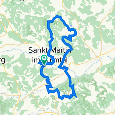
Štýrské vinohrady - den čtvrtý
A cycling route starting in Sankt Martin im Sulmtal, Styria, Austria.
Overview
About this route
The more information you write here, the more useful it will be for other users.* Route progression.* What is special about this route?* Why recommend this route?* What did you like most here?* etc.
- -:--
- Duration
- 38.1 km
- Distance
- 310 m
- Ascent
- 394 m
- Descent
- ---
- Avg. speed
- ---
- Max. altitude

Continue with Bikemap
Use, edit, or download this cycling route
You would like to ride Štýrské vinohrady - den čtvrtý or customize it for your own trip? Here is what you can do with this Bikemap route:
Free features
- Save this route as favorite or in collections
- Copy & plan your own version of this route
- Sync your route with Garmin or Wahoo
Premium features
Free trial for 3 days, or one-time payment. More about Bikemap Premium.
- Navigate this route on iOS & Android
- Export a GPX / KML file of this route
- Create your custom printout (try it for free)
- Download this route for offline navigation
Discover more Premium features.
Get Bikemap PremiumFrom our community
Other popular routes starting in Sankt Martin im Sulmtal
 St. Martiner Genusstour
- Distance
- 33 km
- Ascent
- 565 m
- Descent
- 563 m
- Location
- Sankt Martin im Sulmtal, Styria, Austria
 Otternitz - Eibiswald -Radlpaß - Eibiswald - Arnfeld - Langegg -Arnfels - Otternitz
- Distance
- 79.1 km
- Ascent
- 546 m
- Descent
- 559 m
- Location
- Sankt Martin im Sulmtal, Styria, Austria
 St. Martiner Wirtsleit' Genusstour
- Distance
- 33.1 km
- Ascent
- 554 m
- Descent
- 553 m
- Location
- Sankt Martin im Sulmtal, Styria, Austria
 St. Martin iS auf die Soboth
- Distance
- 97.7 km
- Ascent
- 1,173 m
- Descent
- 1,173 m
- Location
- Sankt Martin im Sulmtal, Styria, Austria
 Otternitz _Kitzeck - Großklein - Otternitz
- Distance
- 52.3 km
- Ascent
- 527 m
- Descent
- 520 m
- Location
- Sankt Martin im Sulmtal, Styria, Austria
 Dörfla 27, St. Martin im Sulmtal nach Badstraße, Pölfing-Brunn
- Distance
- 8 km
- Ascent
- 63 m
- Descent
- 90 m
- Location
- Sankt Martin im Sulmtal, Styria, Austria
 Weinstrasse von Oternitz, Rückweg über Ehrenhausen und Sulmtal
- Distance
- 77.3 km
- Ascent
- 457 m
- Descent
- 457 m
- Location
- Sankt Martin im Sulmtal, Styria, Austria
 prelog
- Distance
- 336.8 km
- Ascent
- 612 m
- Descent
- 609 m
- Location
- Sankt Martin im Sulmtal, Styria, Austria
Open it in the app