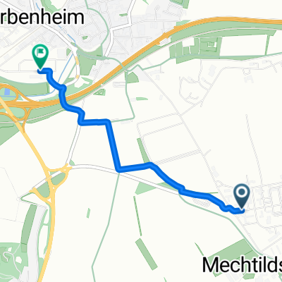
Regionalpark Rhein-Main Tour (40KM)
- 40.1 km
- 140 m
- 140 m
- Hochheim am Main, Hesse, Germany
A cycling route starting in Hochheim am Main, Hesse, Germany.
Overview
Winterrunde (MTB/Crosser) of the Rennrad-News forum thread 'Rennradtreff Wiesbaden/Taunus'. (Almost) Every Tuesday at 5:00 PM. Details see under 'Last-Minute-Radeln' at www.rennrad-news.de. Start at the highway bridge over the A671/Anna-Birle-Straße/Unterer Zwerchweg. Route: Fort Biehler, bicycle/pedestrian bridge over Bölkestraße, concrete paths along the A671, B40, past the adventure playground in Hochheim, towards the landfill/incineration, at the landfill bicycle/pedestrian bridge over B40, continue towards Wiesenmühle, over the wooden plank bridge, singletrail along the Mühlbach, past the industrial monument lime kilns, Bachstraße (Old Hochheimerstraße) to the Main bridge, over the Main, on the Rüsselsheim side below the dike road to Raunheim, Raunheim Kelszterbacherstraße to the level crossing towards Bauersee, after the level crossing left onto the Flörsheimer forest path, follow this to Mönchhof triangle, under the high-voltage line then left over the highway towards Kelsterbach, cross the B43 at Okrifteler Straße and downstream on the Main to the Eddersheimer lock, at the lock cross the Main, after the lock right towards Okriftel, at the end of the village of Eddersheim left on the Posten 19 path, cross the railway line, below the gravel pits towards Weilbach, southwest past Weilbach towards Diedenbergen, cross the railway line towards Massenheim, through Massenheim towards Hochheim, at the village exit of Massenheim right bicycle/pedestrian path towards Delkenheim, along the Wickerbach west of Delkenheim, concrete paths north around Erbenheim airfield towards Erbenheim and continue towards Fort Biehler, cross Bölkestraße again at the bicycle/pedestrian bridge and back to the starting point.
created this 18 years ago
Route quality
Track
34.2 km
(71 %)
Quiet road
4.8 km
(10 %)
Paved
37.6 km
(78 %)
Unpaved
7.7 km
(16 %)
Asphalt
22.1 km
(46 %)
Concrete
11.1 km
(23 %)
Route highlights
Kletterwand / Müllkraftwerk Wicker / Fuss-/Radbrücke über B40
Holzbohlenpfad (Ochsenklavier) vor der Wiesenmühle
Gasthof Wiesenmühle (http://gasthof-wiesenmuehle.business.t-online.de/)
Einstieg zu einem kleinen Singletrail oberhalb des Mühlkanals
Historische Kalköfen
Auffahrt Radweg Mainbrücke
"Trampolin", Einstiegspunkt für die Rüsselsheimer zur Dienstagsrunde (ca. zwischen 17:45 - 18:00)
Bahnübergang
Flörsheimer Waldweg
Autobahnbrücke A67
Autobahnbrücke A3
Radweg bei Okrifteler Fähre (Fussgänger und Radfahrerfähre im Sommer, gibt's die noch?)
Schleuse Eddersheim, (Treppenauf- und -abgang, auf der Schleuse eine 2-stufige Treppe)
Bahnübergang für Fussgänger, Radfahrer und Landwirtschaft (teilweise längere Schließungszeiten, braucht ggf.) etwas Geduld
Brücke über die Schnellbahnstrecke Frankfurt-Flughafen-Köln)
Unterquerung A3 bei Massenheim
Radweg am Ortsausgang von Massenheim
Continue with Bikemap
You would like to ride MTB/Crosser Dienstags-Winterrunde or customize it for your own trip? Here is what you can do with this Bikemap route:
Free trial for 3 days, or one-time payment. More about Bikemap Premium.
Discover more Premium features.
Get Bikemap PremiumFrom our community
Open it in the app