

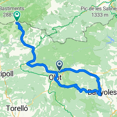
trasa RP d8 dla chetnych
A cycling route starting in Sant Joan les Fonts, Catalonia, Spain.
Overview
About this route
A sample ride for those interested, I can come up with others on the spot. Easy riding, we can arrange lunch in Olot with the whole group.
- -:--
- Duration
- 77.8 km
- Distance
- 1,886 m
- Ascent
- 1,887 m
- Descent
- ---
- Avg. speed
- 1,107 m
- Max. altitude

Route quality
Waytypes & surfaces along the route
Waytypes
Road
54.5 km
(70 %)
Quiet road
9.3 km
(12 %)
Surfaces
Paved
38.9 km
(50 %)
Unpaved
1.6 km
(2 %)
Asphalt
35.8 km
(46 %)
Concrete
2.3 km
(3 %)
Continue with Bikemap
Use, edit, or download this cycling route
You would like to ride trasa RP d8 dla chetnych or customize it for your own trip? Here is what you can do with this Bikemap route:
Free features
- Save this route as favorite or in collections
- Copy & plan your own version of this route
- Sync your route with Garmin or Wahoo
Premium features
Free trial for 3 days, or one-time payment. More about Bikemap Premium.
- Navigate this route on iOS & Android
- Export a GPX / KML file of this route
- Create your custom printout (try it for free)
- Download this route for offline navigation
Discover more Premium features.
Get Bikemap PremiumFrom our community
Other popular routes starting in Sant Joan les Fonts
 Castellfollit - Oix - Beget - Setcases - Vallter 2000 - La Vall del Bac
- Distance
- 117.7 km
- Ascent
- 2,436 m
- Descent
- 2,442 m
- Location
- Sant Joan les Fonts, Catalonia, Spain
 trasa RP d9 powoli konczymy
- Distance
- 68.7 km
- Ascent
- 547 m
- Descent
- 914 m
- Location
- Sant Joan les Fonts, Catalonia, Spain
 Castellfollit - Beget - Camprodon
- Distance
- 77.6 km
- Ascent
- 1,402 m
- Descent
- 1,402 m
- Location
- Sant Joan les Fonts, Catalonia, Spain
 St joan les fonts - Santa Pau - Mieres - Banyoles - Besalu - Castellfollit - St Joan
- Distance
- 82.8 km
- Ascent
- 795 m
- Descent
- 796 m
- Location
- Sant Joan les Fonts, Catalonia, Spain
 VOLTA OLOT JULIOL
- Distance
- 135.5 km
- Ascent
- 2,819 m
- Descent
- 2,817 m
- Location
- Sant Joan les Fonts, Catalonia, Spain
 100% Tondo
- Distance
- 117.4 km
- Ascent
- 2,529 m
- Descent
- 719 m
- Location
- Sant Joan les Fonts, Catalonia, Spain
 17 GARROTXA : St-Joan-les-Fonts Colldecarrera Vall-d'en-Bac St-Miquel-de-la-Torre Llongarriu Capsacosta St-Salvador-de-Bianya
- Distance
- 42.8 km
- Ascent
- 874 m
- Descent
- 858 m
- Location
- Sant Joan les Fonts, Catalonia, Spain
 trasa RP d8 dla chetnych
- Distance
- 77.8 km
- Ascent
- 1,886 m
- Descent
- 1,887 m
- Location
- Sant Joan les Fonts, Catalonia, Spain
Open it in the app