

Floresti - Iacobeni
A cycling route starting in Mălâncrav, Sibiu County, Romania.
Overview
About this route
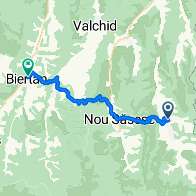
The route starts from the fortified church in Iacobeni and climbs to the top of the hill on the secondary county road DJ 143. From the top of Hula Crișului, it descends on the red cross marker to the village of Florești.
Did you try this trail? If you have identified access problems (missing, damaged or insufficiently clear markings, inaccessible sections etc.) or have suggestions for their improvement, please write to us at colineletransilvaniei@gmail.com. Don't forget to take a GPS point and a few photos – it will help us to intervene faster to fix the situation.
- -:--
- Duration
- 14.9 km
- Distance
- 311 m
- Ascent
- 103 m
- Descent
- ---
- Avg. speed
- 627 m
- Max. altitude

Route photos


Route quality
Waytypes & surfaces along the route
Waytypes
Track
9.4 km
(63 %)
Path
4 km
(27 %)
Quiet road
1.5 km
(10 %)
Surfaces
Unpaved
5.2 km
(35 %)
Unpaved (undefined)
4.6 km
(31 %)
Pebblestone
0.6 km
(4 %)
Undefined
9.7 km
(65 %)
Continue with Bikemap
Use, edit, or download this cycling route
You would like to ride Floresti - Iacobeni or customize it for your own trip? Here is what you can do with this Bikemap route:
Free features
- Save this route as favorite or in collections
- Copy & plan your own version of this route
- Sync your route with Garmin or Wahoo
Premium features
Free trial for 3 days, or one-time payment. More about Bikemap Premium.
- Navigate this route on iOS & Android
- Export a GPX / KML file of this route
- Create your custom printout (try it for free)
- Download this route for offline navigation
Discover more Premium features.
Get Bikemap PremiumFrom our community
Other popular routes starting in Mălâncrav
 03. Biserici fortificate - ziua 3
- Distance
- 24.5 km
- Ascent
- 512 m
- Descent
- 592 m
- Location
- Mălâncrav, Sibiu County, Romania
 Colinele Transilvaniei: Circuit Mălâncrav - Dealul Fetea - Copșa Mare - Nou Săsesc - Mălâncrav
- Distance
- 38.8 km
- Ascent
- 1,021 m
- Descent
- 1,021 m
- Location
- Mălâncrav, Sibiu County, Romania
 Floresti - Iacobeni
- Distance
- 14.9 km
- Ascent
- 311 m
- Descent
- 103 m
- Location
- Mălâncrav, Sibiu County, Romania
 Malancrav - Biertan - Richis
- Distance
- 30.3 km
- Ascent
- 560 m
- Descent
- 593 m
- Location
- Mălâncrav, Sibiu County, Romania
 malancrav - culmea florestilor - floresti - laslea - roandola - nou sasesc - malancrav
- Distance
- 30.5 km
- Ascent
- 427 m
- Descent
- 460 m
- Location
- Mălâncrav, Sibiu County, Romania
 Malancrav - Biertan
- Distance
- 15.4 km
- Ascent
- 479 m
- Descent
- 528 m
- Location
- Mălâncrav, Sibiu County, Romania
 Colinele Transilvaniei: Circuit Mălâncrav - Hula Crișului - Dealul Sneal - Mălâncrav
- Distance
- 18.2 km
- Ascent
- 447 m
- Descent
- 445 m
- Location
- Mălâncrav, Sibiu County, Romania
 Colinele Transilvaniei Day3
- Distance
- 36.3 km
- Ascent
- 634 m
- Descent
- 634 m
- Location
- Mălâncrav, Sibiu County, Romania
Open it in the app