

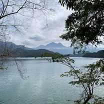
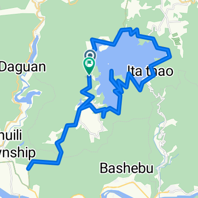
20230112 日月潭
A cycling route starting in Puli, Taiwan, Taiwan.
Overview
About this route
- 4 h 11 min
- Duration
- 18.3 km
- Distance
- 649 m
- Ascent
- 654 m
- Descent
- 4.4 km/h
- Avg. speed
- 826 m
- Max. altitude

Route photos


Continue with Bikemap
Use, edit, or download this cycling route
You would like to ride 20230112 日月潭 or customize it for your own trip? Here is what you can do with this Bikemap route:
Free features
- Save this route as favorite or in collections
- Copy & plan your own version of this route
- Sync your route with Garmin or Wahoo
Premium features
Free trial for 3 days, or one-time payment. More about Bikemap Premium.
- Navigate this route on iOS & Android
- Export a GPX / KML file of this route
- Create your custom printout (try it for free)
- Download this route for offline navigation
Discover more Premium features.
Get Bikemap PremiumFrom our community
Other popular routes starting in Puli
 20230112 日月潭
- Distance
- 18.3 km
- Ascent
- 649 m
- Descent
- 654 m
- Location
- Puli, Taiwan, Taiwan
 20100905 NS武嶺
- Distance
- 53 km
- Ascent
- 3,507 m
- Descent
- 1,492 m
- Location
- Puli, Taiwan, Taiwan
 挑戰武嶺
挑戰武嶺- Distance
- 52.7 km
- Ascent
- 3,880 m
- Descent
- 1,274 m
- Location
- Puli, Taiwan, Taiwan
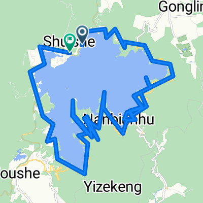
 日月潭環湖(42K)
- Distance
- 42.1 km
- Ascent
- 2,402 m
- Descent
- 2,401 m
- Location
- Puli, Taiwan, Taiwan
 Sun Moon Lake
- Distance
- 42.3 km
- Ascent
- 1,042 m
- Descent
- 1,073 m
- Location
- Puli, Taiwan, Taiwan
 Day 3 From Yuchi Township to Anping District
- Distance
- 185.9 km
- Ascent
- 1,606 m
- Descent
- 2,362 m
- Location
- Puli, Taiwan, Taiwan
 埔里國中→武嶺55km超級坡挑戰賽
- Distance
- 54.6 km
- Ascent
- 2,833 m
- Descent
- 18 m
- Location
- Puli, Taiwan, Taiwan
 20100530 第二屆 武嶺高峰會
- Distance
- 51.8 km
- Ascent
- 2,875 m
- Descent
- 93 m
- Location
- Puli, Taiwan, Taiwan
Open it in the app