

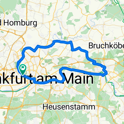
MTB FFM Nordend - Hochstadt - Nordend
A cycling route starting in Frankfurt am Main, Hesse, Germany.
Overview
About this route
Choose the direction of the lap according to the wind direction. With east wind over the Ried, with west wind over the Hohe Straße and back.
- -:--
- Duration
- 29.1 km
- Distance
- 161 m
- Ascent
- 171 m
- Descent
- ---
- Avg. speed
- 206 m
- Max. altitude

Route quality
Waytypes & surfaces along the route
Waytypes
Track
14.3 km
(49 %)
Quiet road
7.3 km
(25 %)
Surfaces
Paved
19.2 km
(66 %)
Unpaved
7.6 km
(26 %)
Asphalt
18.1 km
(62 %)
Gravel
6.1 km
(21 %)
Continue with Bikemap
Use, edit, or download this cycling route
You would like to ride MTB FFM Nordend - Hochstadt - Nordend or customize it for your own trip? Here is what you can do with this Bikemap route:
Free features
- Save this route as favorite or in collections
- Copy & plan your own version of this route
- Sync your route with Garmin or Wahoo
Premium features
Free trial for 3 days, or one-time payment. More about Bikemap Premium.
- Navigate this route on iOS & Android
- Export a GPX / KML file of this route
- Create your custom printout (try it for free)
- Download this route for offline navigation
Discover more Premium features.
Get Bikemap PremiumFrom our community
Other popular routes starting in Frankfurt am Main
 Ffm-Nordend-Wetterau I
- Distance
- 53 km
- Ascent
- 272 m
- Descent
- 246 m
- Location
- Frankfurt am Main, Hesse, Germany
 RG Offenbach-Walldorf
- Distance
- 76.7 km
- Ascent
- 278 m
- Descent
- 276 m
- Location
- Frankfurt am Main, Hesse, Germany
 FFM Mitte - Feldberg
- Distance
- 26.3 km
- Ascent
- 793 m
- Descent
- 21 m
- Location
- Frankfurt am Main, Hesse, Germany
 Rennrad FFM_Ronneburg_FFM
- Distance
- 73.4 km
- Ascent
- 453 m
- Descent
- 405 m
- Location
- Frankfurt am Main, Hesse, Germany
 Nidd-Main-Runde
- Distance
- 57.9 km
- Ascent
- 156 m
- Descent
- 155 m
- Location
- Frankfurt am Main, Hesse, Germany
 FFM-Sachs nach Alkönig Bikepaths
- Distance
- 33 km
- Ascent
- 723 m
- Descent
- 24 m
- Location
- Frankfurt am Main, Hesse, Germany
 Nierrad-Höchst Runde
- Distance
- 21.5 km
- Ascent
- 48 m
- Descent
- 48 m
- Location
- Frankfurt am Main, Hesse, Germany
 Flughafenrunde
- Distance
- 55.9 km
- Ascent
- 98 m
- Descent
- 97 m
- Location
- Frankfurt am Main, Hesse, Germany
Open it in the app