Newbury Street 9 to The Steadings 12, Royal Wootton Bassett
A cycling route starting in Wantage, England, United Kingdom.
Overview
About this route
- 3 h 25 min
- Duration
- 51 km
- Distance
- 347 m
- Ascent
- 320 m
- Descent
- 14.9 km/h
- Avg. speed
- 149 m
- Max. altitude
Route quality
Waytypes & surfaces along the route
Waytypes
Busy road
19.8 km
(39 %)
Road
13.5 km
(26 %)
Surfaces
Paved
23 km
(45 %)
Unpaved
0.7 km
(1 %)
Asphalt
23 km
(45 %)
Gravel
0.7 km
(1 %)
Undefined
27.3 km
(53 %)
Continue with Bikemap
Use, edit, or download this cycling route
You would like to ride Newbury Street 9 to The Steadings 12, Royal Wootton Bassett or customize it for your own trip? Here is what you can do with this Bikemap route:
Free features
- Save this route as favorite or in collections
- Copy & plan your own version of this route
- Sync your route with Garmin or Wahoo
Premium features
Free trial for 3 days, or one-time payment. More about Bikemap Premium.
- Navigate this route on iOS & Android
- Export a GPX / KML file of this route
- Create your custom printout (try it for free)
- Download this route for offline navigation
Discover more Premium features.
Get Bikemap PremiumFrom our community
Other popular routes starting in Wantage
- Newbury Street 9 to The Steadings 12, Royal Wootton Bassett
- Distance
- 51 km
- Ascent
- 347 m
- Descent
- 320 m
- Location
- Wantage, England, United Kingdom
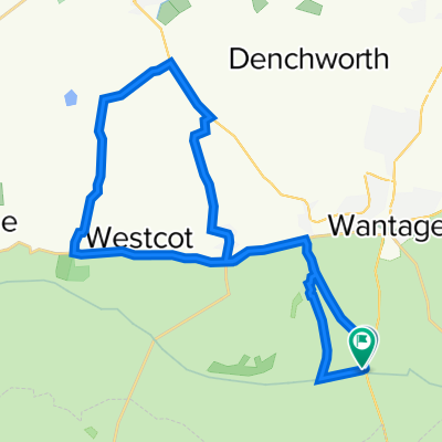
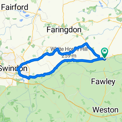
- Wantage-Great Shefford-Lambourn-Ashbury circular
- Distance
- 45.6 km
- Ascent
- 283 m
- Descent
- 280 m
- Location
- Wantage, England, United Kingdom
- Post Office Bungalow, High St, Wantage to Kite House, Aston St, Didcot
- Distance
- 17 km
- Ascent
- 89 m
- Descent
- 129 m
- Location
- Wantage, England, United Kingdom
- Wantge-Swindon circular
- Distance
- 57.9 km
- Ascent
- 220 m
- Descent
- 220 m
- Location
- Wantage, England, United Kingdom
- Short Hill Loop
- Distance
- 41.8 km
- Ascent
- 516 m
- Descent
- 516 m
- Location
- Wantage, England, United Kingdom
- Grove Hanney Denchworth
- Distance
- 15.8 km
- Ascent
- 72 m
- Descent
- 72 m
- Location
- Wantage, England, United Kingdom
- Ickneild Way to Reading Road 2, West Hendred
- Distance
- 15.5 km
- Ascent
- 149 m
- Descent
- 206 m
- Location
- Wantage, England, United Kingdom
- Farnborough/ Peasemore
- Distance
- 51.5 km
- Ascent
- 482 m
- Descent
- 482 m
- Location
- Wantage, England, United Kingdom
Open it in the app