

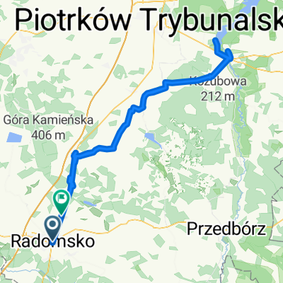
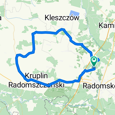
bp2023 d2
A cycling route starting in Radomsko, Łódź Voivodeship, Poland.
Overview
About this route
bp2023 d2
- -:--
- Duration
- 192.2 km
- Distance
- 1,135 m
- Ascent
- 1,176 m
- Descent
- ---
- Avg. speed
- 455 m
- Max. altitude

Route quality
Waytypes & surfaces along the route
Waytypes
Road
115.3 km
(60 %)
Quiet road
36.5 km
(19 %)
Surfaces
Paved
146.1 km
(76 %)
Unpaved
1.9 km
(1 %)
Asphalt
146.1 km
(76 %)
Gravel
1.9 km
(1 %)
Undefined
44.2 km
(23 %)
Continue with Bikemap
Use, edit, or download this cycling route
You would like to ride bp2023 d2 or customize it for your own trip? Here is what you can do with this Bikemap route:
Free features
- Save this route as favorite or in collections
- Copy & plan your own version of this route
- Split it into stages to create a multi-day tour
- Sync your route with Garmin or Wahoo
Premium features
Free trial for 3 days, or one-time payment. More about Bikemap Premium.
- Navigate this route on iOS & Android
- Export a GPX / KML file of this route
- Create your custom printout (try it for free)
- Download this route for offline navigation
Discover more Premium features.
Get Bikemap PremiumFrom our community
Other popular routes starting in Radomsko
 Nad staw
- Distance
- 16.9 km
- Ascent
- 33 m
- Descent
- 48 m
- Location
- Radomsko, Łódź Voivodeship, Poland
 Budowlanych 39, Radomsko do Budowlanych 39, Radomsko
- Distance
- 37.9 km
- Ascent
- 236 m
- Descent
- 245 m
- Location
- Radomsko, Łódź Voivodeship, Poland
 Lipie-Kijów-Radziechowice
- Distance
- 40.1 km
- Ascent
- 246 m
- Descent
- 246 m
- Location
- Radomsko, Łódź Voivodeship, Poland
 szlak radomsko- góra kamieńsk
- Distance
- 48.2 km
- Ascent
- 135 m
- Descent
- 143 m
- Location
- Radomsko, Łódź Voivodeship, Poland
 sulejów
- Distance
- 115.7 km
- Ascent
- 210 m
- Descent
- 205 m
- Location
- Radomsko, Łódź Voivodeship, Poland
 Strażacka 80A, Radomsko do Strażacka 80A, Radomsko
- Distance
- 4.8 km
- Ascent
- 76 m
- Descent
- 67 m
- Location
- Radomsko, Łódź Voivodeship, Poland
 Gminobranie w łodzkiem v.2.
- Distance
- 61.4 km
- Ascent
- 151 m
- Descent
- 151 m
- Location
- Radomsko, Łódź Voivodeship, Poland
 Sucha-Wygoda
- Distance
- 29.5 km
- Ascent
- 260 m
- Descent
- 274 m
- Location
- Radomsko, Łódź Voivodeship, Poland
Open it in the app