

Finca Santa Sofía
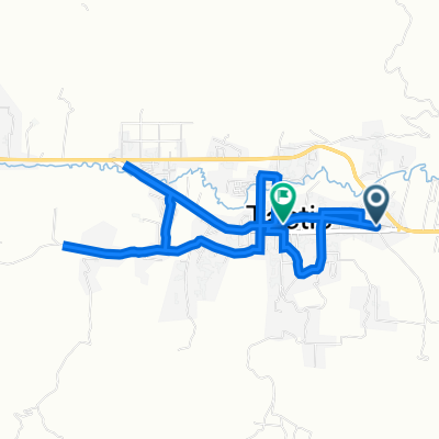
A cycling route starting in Tactic, Alta Verapaz Department, Guatemala.
Overview
About this route
- 1 h 29 min
- Duration
- 8.7 km
- Distance
- 171 m
- Ascent
- 167 m
- Descent
- 5.9 km/h
- Avg. speed
- 1,617 m
- Max. altitude

Route photos


Route quality
Waytypes & surfaces along the route
Waytypes
Quiet road
6.5 km
(74 %)
Road
2.3 km
(26 %)
Continue with Bikemap
Use, edit, or download this cycling route
You would like to ride Finca Santa Sofía or customize it for your own trip? Here is what you can do with this Bikemap route:
Free features
- Save this route as favorite or in collections
- Copy & plan your own version of this route
- Sync your route with Garmin or Wahoo
Premium features
Free trial for 3 days, or one-time payment. More about Bikemap Premium.
- Navigate this route on iOS & Android
- Export a GPX / KML file of this route
- Create your custom printout (try it for free)
- Download this route for offline navigation
Discover more Premium features.
Get Bikemap PremiumFrom our community
Other popular routes starting in Tactic
 De pasmolon
- Distance
- 18.9 km
- Ascent
- 454 m
- Descent
- 439 m
- Location
- Tactic, Alta Verapaz Department, Guatemala
 Atletismo
- Distance
- 4.4 km
- Ascent
- 71 m
- Descent
- 71 m
- Location
- Tactic, Alta Verapaz Department, Guatemala
 Montaña Chojol
- Distance
- 10.7 km
- Ascent
- 283 m
- Descent
- 287 m
- Location
- Tactic, Alta Verapaz Department, Guatemala
 najkitop
- Distance
- 15.8 km
- Ascent
- 269 m
- Descent
- 273 m
- Location
- Tactic, Alta Verapaz Department, Guatemala
 entrenamiento nocturno femenino No.3
- Distance
- 4.8 km
- Ascent
- 47 m
- Descent
- 47 m
- Location
- Tactic, Alta Verapaz Department, Guatemala
 Finca Santa Sofía
- Distance
- 8.7 km
- Ascent
- 171 m
- Descent
- 167 m
- Location
- Tactic, Alta Verapaz Department, Guatemala
 vuelta a najquitob, cruce del Cid.
- Distance
- 20.5 km
- Ascent
- 263 m
- Descent
- 267 m
- Location
- Tactic, Alta Verapaz Department, Guatemala
 Colazo nocturno Bomberos Voluntarios
- Distance
- 9.4 km
- Ascent
- 78 m
- Descent
- 87 m
- Location
- Tactic, Alta Verapaz Department, Guatemala
Open it in the app