

2011_Sofia-Budapest_03
A cycling route starting in Aleksinac, Central Serbia, Serbia.
Overview
About this route
-
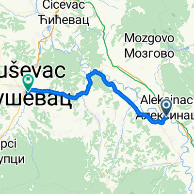
Etappe (15.08.2011):
Start: Wildcampen bei Nis
Ziel: Wildcampen bei Glogovac
- -:--
- Duration
- 104.5 km
- Distance
- 334 m
- Ascent
- 363 m
- Descent
- ---
- Avg. speed
- ---
- Max. altitude

Route quality
Waytypes & surfaces along the route
Waytypes
Road
9.4 km
(9 %)
Quiet road
9.4 km
(9 %)
Surfaces
Paved
79.4 km
(76 %)
Unpaved
5.2 km
(5 %)
Asphalt
79.4 km
(76 %)
Gravel
3.1 km
(3 %)
Continue with Bikemap
Use, edit, or download this cycling route
You would like to ride 2011_Sofia-Budapest_03 or customize it for your own trip? Here is what you can do with this Bikemap route:
Free features
- Save this route as favorite or in collections
- Copy & plan your own version of this route
- Split it into stages to create a multi-day tour
- Sync your route with Garmin or Wahoo
Premium features
Free trial for 3 days, or one-time payment. More about Bikemap Premium.
- Navigate this route on iOS & Android
- Export a GPX / KML file of this route
- Create your custom printout (try it for free)
- Download this route for offline navigation
Discover more Premium features.
Get Bikemap PremiumFrom our community
Other popular routes starting in Aleksinac
 2011_Sofia-Budapest_03
- Distance
- 104.5 km
- Ascent
- 334 m
- Descent
- 363 m
- Location
- Aleksinac, Central Serbia, Serbia
 Чокотино брдо мазохизам
- Distance
- 41.9 km
- Ascent
- 289 m
- Descent
- 334 m
- Location
- Aleksinac, Central Serbia, Serbia
 Route naar Cara Dušana 31, Beograd
- Distance
- 206.9 km
- Ascent
- 1,460 m
- Descent
- 1,534 m
- Location
- Aleksinac, Central Serbia, Serbia
 BALKAN 13/ Aleksinac - Leskovac
- Distance
- 76.8 km
- Ascent
- 153 m
- Descent
- 97 m
- Location
- Aleksinac, Central Serbia, Serbia
 WI_Tag_4: Aleksinac_Ravno pole
- Distance
- 235.9 km
- Ascent
- 951 m
- Descent
- 594 m
- Location
- Aleksinac, Central Serbia, Serbia
 Aleksinac - Vucje
- Distance
- 107 km
- Ascent
- 365 m
- Descent
- 265 m
- Location
- Aleksinac, Central Serbia, Serbia
 TI - D10 - Aleksinac - Pirot
- Distance
- 106.2 km
- Ascent
- 676 m
- Descent
- 479 m
- Location
- Aleksinac, Central Serbia, Serbia
 2020_BG_Nis_Day3
- Distance
- 80.5 km
- Ascent
- 132 m
- Descent
- 68 m
- Location
- Aleksinac, Central Serbia, Serbia
Open it in the app