

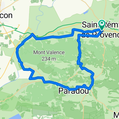
Saint Remy de Provence to Observation Point above Les Baux and return
A cycling route starting in Saint-Rémy-de-Provence, Provence-Alpes-Côte d'Azur Region, France.
Overview
About this route
Nice backroads run with stiff climb to observation point, then off road run back down to Saint Remy.
- -:--
- Duration
- 21.6 km
- Distance
- 307 m
- Ascent
- 308 m
- Descent
- ---
- Avg. speed
- ---
- Max. altitude
Continue with Bikemap
Use, edit, or download this cycling route
You would like to ride Saint Remy de Provence to Observation Point above Les Baux and return or customize it for your own trip? Here is what you can do with this Bikemap route:
Free features
- Save this route as favorite or in collections
- Copy & plan your own version of this route
- Sync your route with Garmin or Wahoo
Premium features
Free trial for 3 days, or one-time payment. More about Bikemap Premium.
- Navigate this route on iOS & Android
- Export a GPX / KML file of this route
- Create your custom printout (try it for free)
- Download this route for offline navigation
Discover more Premium features.
Get Bikemap PremiumFrom our community
Other popular routes starting in Saint-Rémy-de-Provence
 St Rémy-Lac du Peiroou
- Distance
- 6.1 km
- Ascent
- 149 m
- Descent
- 150 m
- Location
- Saint-Rémy-de-Provence, Provence-Alpes-Côte d'Azur Region, France
 Provence: Les Baux-de-Provence
- Distance
- 49.6 km
- Ascent
- 843 m
- Descent
- 708 m
- Location
- Saint-Rémy-de-Provence, Provence-Alpes-Côte d'Azur Region, France
 St Remy-Roc des Alpilles
- Distance
- 39.3 km
- Ascent
- 462 m
- Descent
- 462 m
- Location
- Saint-Rémy-de-Provence, Provence-Alpes-Côte d'Azur Region, France
 Saint-Rémy-de-Provence fin séjour
- Distance
- 43.8 km
- Ascent
- 318 m
- Descent
- 314 m
- Location
- Saint-Rémy-de-Provence, Provence-Alpes-Côte d'Azur Region, France
 Dia 6C - Saint-Remy-de-Provence a Nimes
- Distance
- 65.7 km
- Ascent
- 221 m
- Descent
- 237 m
- Location
- Saint-Rémy-de-Provence, Provence-Alpes-Côte d'Azur Region, France
 St Rémy-Glanum-Rocher des 2 trous
- Distance
- 6.9 km
- Ascent
- 272 m
- Descent
- 273 m
- Location
- Saint-Rémy-de-Provence, Provence-Alpes-Côte d'Azur Region, France
 St Remy Les Baux
- Distance
- 41.1 km
- Ascent
- 312 m
- Descent
- 312 m
- Location
- Saint-Rémy-de-Provence, Provence-Alpes-Côte d'Azur Region, France
 StRemy - 75-100
- Distance
- 73.7 km
- Ascent
- 122 m
- Descent
- 124 m
- Location
- Saint-Rémy-de-Provence, Provence-Alpes-Côte d'Azur Region, France
Open it in the app