

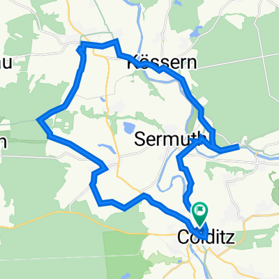
Colditz
A cycling route starting in Colditz, Saxony, Germany.
Overview
About this route
- -:--
- Duration
- 61.9 km
- Distance
- 788 m
- Ascent
- 785 m
- Descent
- ---
- Avg. speed
- 313 m
- Max. altitude

Route quality
Waytypes & surfaces along the route
Waytypes
Quiet road
30.3 km
(49 %)
Road
20.4 km
(33 %)
Surfaces
Paved
40.8 km
(66 %)
Unpaved
2.5 km
(4 %)
Asphalt
38.4 km
(62 %)
Paved (undefined)
2.5 km
(4 %)
Continue with Bikemap
Use, edit, or download this cycling route
You would like to ride Colditz or customize it for your own trip? Here is what you can do with this Bikemap route:
Free features
- Save this route as favorite or in collections
- Copy & plan your own version of this route
- Sync your route with Garmin or Wahoo
Premium features
Free trial for 3 days, or one-time payment. More about Bikemap Premium.
- Navigate this route on iOS & Android
- Export a GPX / KML file of this route
- Create your custom printout (try it for free)
- Download this route for offline navigation
Discover more Premium features.
Get Bikemap PremiumFrom our community
Other popular routes starting in Colditz
 E6 Colditz - Strauch
- Distance
- 71.6 km
- Ascent
- 218 m
- Descent
- 232 m
- Location
- Colditz, Saxony, Germany
 Forsthof 12, Colditz nach Forsthof 9, Colditz
- Distance
- 25.3 km
- Ascent
- 233 m
- Descent
- 274 m
- Location
- Colditz, Saxony, Germany
 Forsthof 9, Colditz nach Bahnhofstraße 16, Colditz
- Distance
- 60.2 km
- Ascent
- 429 m
- Descent
- 421 m
- Location
- Colditz, Saxony, Germany
 Colditz, Colditz nach Penna, Rochlitz
- Distance
- 26.3 km
- Ascent
- 314 m
- Descent
- 330 m
- Location
- Colditz, Saxony, Germany
 Eibenstock Hamburg Teil 2
- Distance
- 91.5 km
- Ascent
- 25 m
- Descent
- 77 m
- Location
- Colditz, Saxony, Germany
 32. ITF BERLIN-ROM -- 2. Etappe 148 km
- Distance
- 147.4 km
- Ascent
- 1,313 m
- Descent
- 1,088 m
- Location
- Colditz, Saxony, Germany
 Geithain - Honbach_Alternativen zur Tour 19483
- Distance
- 26.4 km
- Ascent
- 227 m
- Descent
- 159 m
- Location
- Colditz, Saxony, Germany
 Zschetzsch - Sermuth - Schönbach - Honbach
- Distance
- 28.1 km
- Ascent
- 221 m
- Descent
- 221 m
- Location
- Colditz, Saxony, Germany
Open it in the app